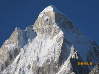
Bagini Glacier
 |
| Bagini Glacier |
The Bagini Glacier drains the snows of several peaks that form part of the near-impassable Northern Rim of the Nanda Devi Sanctuary in Eastern Garwhal. The glacier seeds the Dronagiri Gad, a feisty stream that descends a valley north-westwards to meet the west-bound Dhauli Ganga at a village called Jumma. In turn, the Dhauli meets the Alaknanda at Vishnuprayag, the first of numerous major prayag’s below Badrinath that serve as markers for the high course of the Ganga.
On this trek, though we couldn’t see
the iconic peak, we were well aware of its presence. In 1934 Eric Shipton,
legendary British mountaineer of his time, along with the American Bill Tillman,
made history by pioneering a route via the Rishi Ganga to gain access to the
Inner Sanctuary of Nanda Devi. Two years later, Shipton returned to the sanctuary, and
climbed out of it via the “Bagini Pass”, part of this Northern Barrier. He exited
via our exact trekking route. The geography and the history of exploration of the
surroundings were weighing pleasantly on my mind as we planned and embarked on
this trek. It would also mark a step up for the kids (Ishan 8, and Samarth 12) in
terms of difficulty levels, remoteness, and altitude.
This trip was over a year in the making. Plans fell through
in 2021, and we ended up trekking the popular, but nonetheless thoroughly enjoyable
Har-Ki-Dun
and Ruinsara Valleys. Finally,
things fell into place this year. The four of us, and three friends from Runners High – Atrei,
Paroma and Ravish – planned this trip during the Durja Pujo/Dussehra holidays
of 2022. Our friend and guide Gyan would help with logistics.
Sep 23: Bangalore to Delhi and Overnight in the Nanda
Devi Express
An 8:30 pm arrival into IGI Delhi and an 11:50 pm departure
from Nizamuddin Railway Station provides enough buffer for reasonable delays
and the 45 min drive from the airport to the train station. In 2019, we had to
kill over two hours in the cafeteria outside Nizamuddin. This year, that was
not to be repeated, partly because the cafeteria had shut down, but mainly
because our flight was 2 hours late, thanks to torrential rain in Delhi which
delayed the departure from Bangalore. To compound matters, there was significant traffic congestion in the New Delhi
airspace. I
managed to forget my backpack on the conveyor belt, words were exchanged at the
Prepaid Taxi booth, and we found new ways to cram ourselves with our backpacks into
the interiors of two kaali-peelis where CNG cylinders had usurped most of the boot
space, and the rooftop luggage racks were out of commission thanks to the
downpour. For some reason, our driver had his wipers set to intermittent even
though the rain was pouring in sheets. He peered his way through New Delhi’s
fast-moving but poorly lit tree-lined avenues. Paroma said their guy made it a
point to run every red light he encountered. Amazingly, both taxis reached Nizamuddin
in one piece each, giving us about 20 minutes before we boarded the Nanda Devi
Express (also known officially as the less exciting “Kota Dehradun Express”).
Sep 24: Dehradun to Rudraprayag (Shivanandi River Lodge)
We arrived at Dehradun station soon after daybreak, and
hiked the 500m or so to Hotel Ashrey, a convenient pit-stop for breakfast and
showers before the long dusty road trip up the Alakandanda Valley. Our start
was delayed due to suspect brakes on the first vehicle we were assigned. The
replacement Bolero only arrived at 10:00, which gave us an opportunity to have
a hearty parantha and omelet breakfast (which made up for the missed dinner the
previous evening), take a walk around the hotel area, and browse through the
interesting collection of photos, posters and “stuff” in the Ashrey lounge.
This included a real-life Bullet Motorcycle, suspended from the ceiling, under
which the kids played a couple of rounds of snakes and ladders.
 |
| Devprayag |
 |
| Shivanandi River Lodge |
 |
| GMVN Eco Lodges at Auli |
 |
| Chair lift to get there |
The road trip was uneventful, but remarkable for the improvement in quality of road surface, signage and safety barriers. We made steady progress with no major hold ups due to landslides, past the landmarks of Rishikesh, famous for its ashrams and hippie culture, Devprayag, where the waters of the Bhagirathi and Alaknanda merge to form the Ganga, Srinagar, the medieval capital of Garwhal, and Rudryaprayag, the meeting point of the Mandakini and Alaknanda rivers, and turn off for Kedarnath. About 12 km beyond Rudraprayag, at around 4 pm, at a non-descript bend on the highway, we stopped and hiked a hundred meters down a rocky forested path to the left into a lovely guest house by the banks of the Alaknanda River, called “Shivanandi River Lodge”.
Shalabh, who runs this place in the company of his three
dogs (Prince, Chocho and Suru) was a knowledgeable, helpful, and considerate
host. Strongly recommend his place to while away a few days, or use it (like
us) as a staging point for deeper forays into the higher Himalayas. The kids
loved the company of the dogs, the rooms were large and comfortable, the food
was fresh, homely, and nutritious. and the supply of tea was endless. We got a
room with a loft, and Ishan and Samarth made a beeline for the cosy upstairs. Our
driver Ali wasn’t too happy about the lack of facilities for him, but he
couldn’t suggest that he wasn’t warned.
Sep 25: Rudraprayag (Shivanandi) to Auli (3050 m / 10,000
ft)
We reached Auli at about 3 pm with the intent of spending one night for acclimatization. It was more built up than what we saw on our 2007 visit. A fragile “chair lift” took us up to the cottages of GMVN’s “Eco Nature Resort” where we had reservations. The lift was an interesting experience – little to no instructions were provided for safety, one moment we were waiting with our packs, and a few seconds later, we were off, lurching in our seats, looking at the ground falling away from underneath us with more than a little alarm. From the drop-off point it was a couple of hundred meters of hiking to the cottages. The cottages were spacious, interconnected by sloping paths. The facility was thinly staffed, a little incongruous in its use of concrete for the paths and tin roofs for covering them. No views were on offer that evening except for an arguable outline of the Goddess.
Sep 26: Road Closure and Joshimath
The morning was clear, with a smattering of clouds hovering around the peaks of the Zanskar Range to the north, beyond which lies the Valley of Flowers. We hiked uphill from the cluster of cottages towards the high point of the chair lift, enjoying the cold mountain air and the sunshine. I was particularly tickled by a question from a local who asked if I was a guide and the others were my party. I guess my trekking clothes look worn enough! Nanda Devi (7816 m) made her appearance, in shadow since the sun rises behind her. We returned quite quickly for breakfast and prepared ourselves better for the chair lift. After some confusion we sorted out which driver was supposed to take us back towards Joshimath and on towards the trail head.
 |
| Nanda Devi (7816 m), from Auli |
 |
| Jalebis in Joshimath |
Earlier in the day, we met a trekker from Bangalore who had
just trekked the Panpatia Col,
a high-altitude route connecting Kedarnath to Badrinath. He seemed like a
fiercely independent solo trekker, with lots of experience.
Sep 27: Joshimath to First Campsite (Beyond Ruing), about
3050 m / 10,000 ft
We left Joshimath at 8:00, hopeful that the road would be
open. Fortunately, we passed the site of the landslide uneventfully, and
stopped for a Maggi breakfast soon after. The village had posters of the
upcoming Nanda Devi yatra, a 2-3 week-long festival in these parts, and an
important event in the cultural calendars of both Garwhal and Kumaon. Our driving
route hugged the Dhauli Ganga as we headed east. It was a beautiful valley with
not much traffic and a surprisingly good quality road. The road leads up
the valley all the way to the vicinity of Mt Kamet, at 7756 m, the second highest
peak in this region (after Nanda Devi) near the Tibet border. An hour or so after
breakfast, our route turned right onto a jeep track, and we were able to drive
to the village of Ruing. At 10:30 am, we bade the jeeps farewell.
 |
| Somewhere beyond Ruing |
Sep 28: Beyond Ruing to Longatulli (3800 m / 12,500 ft)
The next day we left camp at 8:00 am, and hiked through a
landslide area that was far less initimidating than what online trip reports
had suggested. We took the upper route on the advice of locals and Gyan, the opposite of
what is recommended by Indiahikes. Our mules took the lower route. The
trail remained “Nepali Flat” for a while, before steadily ascending a broad
face towards the perfectly perched village of Dronagiri at the base of the eponymous
mountain. Dronagiri village faces north, where across the Dhauli Valley, stands
the Zanskar Range, containing several peaks over 6000m (Hathi & Ghori
Parvats, and Brahmakamal), beyond which lies the Valley of Flowers. In fact, my
reading companion for the trip was “Valley of Flowers”, Frank Smythe’s 1937
account of exploring and documenting its geography and flora.
 |
| Dronagiri Village |
The trail crossed a ridge to the east of the village (our
left), with the rock and ice walls of the 7000 m Dronagiri peak standing over it’s
western parts. It then descended into the broader, glacier-fed Dronagiri
Gad valley. We lunched in the shelter of a large boulder just where the trail
crossed over to the true right of the river. From here on, the views gradually
opened up, with Rishi Pahar (6992 m) increasingly dominating the view at the head
of the valley. By 1:30 pm, we were at the campsite. We located ourselves a bit
away from the river after spotting another group of trekkers (actually the only
group that we came across on the entire trip) camped closer to it. Some folks
in that party weren’t feeling well and had stayed back at camp while the others
had gone day hiking for glacier views. Ishan and Samarth found a large boulder
that they scampered up and down, enjoying from its crest, a sun-and-clouds view
of the Zanskar range to the north, Rishi Pahar to the south, and flanks of Dronagiri
to the west.
 |
| Longatuli Campground (2nd campsite), Rishi Pahar at the valley head |
Sep 29: Longatulli Rest Day (3800 m / 12,500 ft)
Paroma, the kids, and I decided to stay put at the campsite,
attending to chores, cleaning up, playing endless rounds of Uno, Contact, and
Pictionary, while Atrei, Ravish and Ranjita moved up the valley for a day hike
on the same trail that we would hike up the next day.
 |
| Company at Longatulli |
I woke up early and hiked up the large boulder to grab some
sunrise shots, and was amply rewarded with views of what was possibly Hathi
Parvat (6727 m) in the Zanskar range. To the west, a snow peak that likely was
a subsidiary peak of Dronagiri showed itself. At around 8:30 am, in clear
sunshine, we packed up our stuff, and started to inch up the valley towards the
giant moraine, with the expectation of views of the glacier later in the day. I
was moving slowly (even slower than my usual uphill trudge), feeling the
effects of altitude as we progressed. By about 10:00, we were on top of the
moraine, looking back at the broad river valley and glacial melt we were
leaving behind. The higher elevation gave us views of a set of new peaks, which
together formed the Northern Barrier of the Nanda Devi Sanctuary. We would get
to know their names as we got closer and would correlate their positions with
the topo map.
 |
| It was a slow but inspiring climb up the moraine |
 |
| Rishi Pahar (6992 m) and the Bagini Terminal Moraine |
 |
| Hathi Parvat ? in the Zanskar Range |
 |
| Sat Minal (6911 m) |
 |
| Bagini Glacier |
 |
| Chortens or chimneys? |
The walk along the true right of the Bagini Glacier was well
under way. The terrain had largely flattened out, the tree line had been left
behind, and a landscape of rocky debris surrounded us with violet and yellow
wildflowers dotting the ground in the spaces between boulders. Dronagiri
towered over us to the right (though the peak was not visible), and the snow
giants protecting the Goddess awaited us in front, fortress like.
Finally, around 2 pm, we reached our campsite: a few steps from
the glacier’s right lateral moraine. Standing alongside a few chortens on the
moraine, we received views of the (expected) boulder strewn, wave-like Bagini
Glacier, a freeze frame of moving ice and rock, draining the snows from all the
peaks at the head of the valley. At this time, the clouds rolled in, obscuring
the blue sky and snow peaks, making the desolation of the glacier even more
pronounced. It was at least half a kilometer wide, and judging by what we
ascended, at least a couple of hundred feet deep.
That evening we decided not to move camp any higher to avoid any risk of AMS, and would limit ourselves to an optional day hike the next day to see if we could spot the the “Shining Mountain”, the elusive Changabang (6864 m).
Oct 1: Bagini Glacier Day Hike (15,500 ft) and Return to Dronagiri
(11,000 ft)
Thin clouds with bright blue patches of sky in between greeted
us at camp early in the morning. Through them Rishi Pahar shone through, our
constant companion since the day before. On our right, clouds were lifting from
the glacier, giving the chortens a chimney-like appearance. Frost on our tents and
on flat boulders told us the temperature had fallen below zero overnight. The
sun, piercing through the clouds, bounced off the snowy patches on the glacier.
Since the weather wasn’t guaranteeing us views of Changabang
(6864 m), Manoj led rolling up the campsite and descending (with Atrei) while
the rest of us, along with Gyan, got started on the day hike to give ourselves a closer view of the peaks.
Changabang notwithstanding, the walk was spectacular. The ground
gradually morphed from rocky debris into meadow-like terrain.
The grasslands were interspersed with patches of red wild Ramdana (amaranthus).
Small streams flowed down the western slopes towards the glacier. Delicate
flowers dotted the landscape. Though not cloudless, the sky remained a
brilliant blue, and as we walked towards the amphitheater of peaks at the head
of the valley, it built up some anticipation for views of Changabang. There
were none to be had. But we were more than content with views of Tirsul (7074
m), Hardeol (7151 m), Rishi Pahar (6992 m), Sat Minal (6911 m) and Kalanka
(6931 m).
 |
| Sat Minal (6911 m) |
 |
| Wild Ramdana |
 |
| Near the turn around point. 15,500 ft |
 |
| Kalanka (6931 m) |
 |
| Bagini Glacier |
 |
| Tirsul (7074 m) and Hardeol (7151 m) |
 |
| Meadows above Bagini |
 |
| Poorvi Dronagiri |
 |
| Rishi Pahar (6992 m) |
15 years ago, several folks (including myself and Ranjita) spent
many hours at and after Kuari Pass debating whether we saw Changabang and
Kalanka from that vantage point, and if so, which ones they were. I revisited that dilemma from Chandrashila Peak a few years ago. The hope was
that this trip would put matters to rest, by viewing both those magnificent
peaks at close range. But we succeeded only partially!
GPS reports variously suggested we were between 15,500 and
16,000 ft. At this point (around 10:30 am) we decided to turn around, enjoy the
rest of the morning’s walk back, and catch up with Atrei.

We retraced our steps through our last campsite. At some point looking back the way we were descending, I spotted a tiny protuberance on an otherwise flat ridge between two of the peaks heading the valley. It seemed very possible that it was the summit of Nanda Devi. We continued past Longatulli, where the kids quickly scampered up and down their favorite boulder. Soon we met Atrei, a little before the descent to the river crossing before Dronagiri village. Her guide, a camp-helper, had mistakenly taken her on a 45 min detour earlier. At her (wise) insistence, he turned around to catch up with us. Later the staff would make fun of him by calling him “guide-saab”. Relieved and reunited, we scrambled down the steep gravelly trail to the river (collectively wondering how we couldn’t recall this difficult stretch on the way up), and then made the trudge up to Dronagiri village.
At Dronagiri, we camped a couple of hundred feet above the village. A GMVN guest house was under construction at some distance, and it’s unimaginative modern design looked out of place amidst the traditional architecture. I also wondered if it would be commercially viable given how remote and deserted Dronagiri village is. I
It was considerably warmer than higher up. Most of us washed up, lounged
about in the meadow, and had pakoras made from local potatoes for snacks.
 |
| Dronagiri Village |
 |
| Celebratory snacks! |
 |
| Boulder at Longatuli |
Oct 1: Walk out to Ruing (9000 ft)
We got started at 7:30 am, and walked through the village on
a concrete path, and then through some tall grasses down the wide slope. Very
quickly, we were back in the narrow gorge we started the trek in, and made fast
progress through the landslide, past our first campsite (by 9:00). By 11:00, we
were at the jeep road. We had to wait till about noon before our jeeps showed
up. As we drove back to Joshimath, we were treated to a hit song (played on
repeat) that extolled the virtues of prominent Gujaratis, including Modi,
Ambani, and Gandhi. What it lacked in artistic merit, it made up for in
catchiness. Soon we were all humming the song with peals of laughter as we made
our way past the confluence of the Rishi and Dhauli Ganga, gawked at brief but stunning
views of Nanda Devi, and enjoyed an unexpectedly good meal at the Bawarchi
Restaurant in Joshimath (followed by jalebis at anti-inflationary prices).
We parted ways here – Gyan and Manoj left quickly for their
long trip back to Uttarkashi and Dhunda. Samarth, Paroma, Ravish and Atrei headed down
to Rudraprayag for the night and to Rhishikesh and beyond from there. Ranjita,
Ishan and I found a willing cab to take us to Badrinath for the night.
Badrinath was in general, a mess, thanks to a “smart city” project, and dense crowds thanks to "Maha Ashtami". Next morning, Ranjita nursed a minor bug, while I
made the short march out to Mana and back. A day later, we were back in
Shivanandi River Lodge near Rudraprayag, followed by an unexpectedly difficult road trip back to
Hardwar, where we took the evening train to Delhi.
Closing Thoughts:
There’s a lot of misinformation about this trail online.
It’s not as hard as it is made out to be. It is high altitude though, so extra
days on the ascent are crucial. We lost a day due to the road closure, so we
didn’t have time to explore the higher reaches of the valley. With one more
day, we could probably have done one more camp, or a longer day hike to allow
for higher success with viewing Changabang and other peaks.
Trekking through these high valleys makes you marvel and worry about the fragility and serendipity of the geography and ecology that sustains most of Northern India. A minor glitch in monsoon patterns, or a tectonic shift that forces these headwaters to change direction --- it could change life as we know it for the hundreds of millions in the Gangetic Basin.

Comments