Har Ki Dun and Ruinsara Tal
 |
| Banderpoonch range from the Ruinsara Valley |
 |
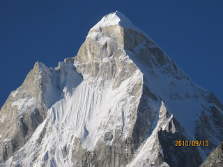
| Swargarohini I and the Har Ki Dun Valley |
At 20,500 ft Swargrohini is not significant in terms of
altitude, but what it lacks in numbers it makes up in relief and prominence,
rising in a majestic sweep of 8000 ft of rock and ice from the giant meadows below
it. Beyond the Swargrohini Massif lies the Ruinsara Valley to the south, where
the Ruinsara Gad drains the glaciers of the Banderpoonch Range and Kalanag.
Together with Swargrohini, this group of peaks form the headwaters of the
Yamuna; a divide separating it from the waters of the Bhagirathi. The local and
downstream topographies are such that even though here, the waters of the
Yamuna and Ganga are separated by only 25 km or so (in straight line terms),
they finally get to meet over a thousand kilometers away at Allahabad. The trek
to Ruinsara Tal is not as popular as the one to Har-Ki-Dun but is highly rewarding,
and well worth the extra few days it adds to the itinerary.
This was my second trip to Har-Ki-Dun, and my first to
Ruinsara Tal. It was something of a last-minute plan. For a few weeks, we were
looking forward to returning to the Himalayas after a 2 year long pandemic-induced
hiatus and had zeroed in on the Bagini Glacier near the Northern Sanctuary of
Nanda Devi during the week of Diwali. But for a variety of reasons, it was not
to be. So, with only a week’s planning, we left for these lovely valleys of
Western Garhwal with two kids – Ishan (7) and Samarth (11). Given how they
enjoyed our trek to Kyarkoti Lake (not to be confused with Kyarkoti meadows
near Ruinsara Tal) two years earlier, my familiarity with Har-Ki-Dun from a
2013 trail run, and the judgment and experience of our guide, I was confident
they would do fine on this route. Given the short notice, none of our other
trekking buddies were able to make it, so it was just the four of us, in the
reliable company of Gyan, our friend and guide from Dunda/Harsil (the two
places he calls home).
7th October: Bangalore to Jharipani
As with the Kyarkoti trip 2 years ago, we made a solid plan
for the outbound portion of our journey, but left things flexible for the
return with enough buffer days before our return flight to Bangalore. This gave
us the freedom to decide exactly when to finish the trek. Would we go to
Ruinsara Tal? Visit Yamunotri? Or return to Musoorie and spend a couple of
nights in relative comfort? All options were on the table as we hurtled from
the Jolly Grant Airport in the hands of the aggressive driver of our Etios. I made
a self-note not to hire a taxi in the future from unknown operators in the
future (in spite of high ratings on Google Reviews) especially when heading deep
into the mountains. Two stressful hours later, just as evening was falling over
the Dehra Dun Valley we reached our night halt; a quaint little hotel called
Jharipani Castle, about 5 km before Musoorie.
It was a pleasant evening, with a beagle named Milo keeping the kids
entertained, along with a model Ambassadors, and a WWII era Willys Jeep on
display. The “mandva roti” (which turned out to be Ragi) with the local chicken
curry made for an excellent meal, and the kids were quite pleased with the log
cabin rooms. I went out for a walk after dinner to get into the mountain groove
but felt a bit nervous on the steep dark streets with howling dogs, so came
back soon enough. We also decided that taking the Etios all the way to Sankhri
was not a good idea (with my memory of a notoriously bad stretch of road above
Purola from my last trip). So I called Gyan, who would be traveling from
Uttarkashi to Sankhri the next morning, and arranged to rendezvous with him at
Purola around lunch time, and get a ride with him in his Bolero for the rest of
the journey.
Oct 8: Jharipani to Sankhri (2000m / 6500 ft)
 |
| Sankhri |
We left Jharipani at 8:30 am, and moved slowly through the
congestion around Musoorie and the next 13 km to Kempty Falls, marked by an
ugly row of shops and restaurants catering to crowds of tourists. Soon after
Musoorie, the highway takes you through a sliver of the Tehri Garwhal district
before passing into Uttarkashi district. With our driver having been instructed
to drive slowly, it was nevertheless an uncomfortable journey through Damta
(where we stopped around 11 for a break), Nowgaon, where the route takes a left
to leave the main Yamuna valley and head up the Tons instead, finally reaching
Purola around 1 pm. We were quite relieved to jetison the Etios; the four
of us climbed into the back seat of Gyan’s Bolero. Poor Ram (Gyan’s Nepali helper
from Dunda who we’d get to know better on the trek) was relegated to the back,
where he spent the next 2 hours cramped up between a gas cylinder, several
backpacks, and 8 days’ worth food supplies. It was a pleasure to meet Gyan. Since
lunch was going to be delayed, he had had the foresight to keep fresh apples
from his orchard in Harsil accessible, which we all wolfed down.
Our driver would have to drive back down the same day, so we skipped the
planned lunch halt at the very busy market street of Mori and pushed on to
Sankhri, which we reached at 3 pm, and got deposited in front of the
Swargrohini Hotel, which provides basic but functional overnight stays to trekkers.
Sankhri was far busier than what I recollected from my 2013
visit. The trekking scene had returned, thanks in part to large commercial
outfits like Trek-The-Himalayas and IndiaHikes. We saw jeep-loads of trekkers
landing up, and other groups who had finished their trek hanging around outside
the only kirana store that would offer an hour’s worth of WiFi access for Rs 50
to inform their families about their safe return to “base camp”. The state-run GMVN
lodge (which was already in poor shape in 2013) had shut down completely and
had apparently given way to private enterprise.
Gyan went about making arrangements for a jeep to take us to
Taluka (or as far as the road would allow) the next morning. In the process he discovered
that the permits he had obtained in Uttarkashi were no good, hence our start
would be delayed until the local officer issued fresh ones. We escaped the
hustle and bustle of downtown Sankhri and went for an easy and pleasant walk on
a road that curves up and away from the main village offering great views of
the mountains and the deep valleys carved by the Tons and Supin rivers. Later
in the evening, we sorted through our gear, choosing what to leave behind in
Sankhri and what to carry on the trek. Samarth and I shared a room with a giant
black spider who spent the whole night unobtrusively behind our bed, who would
have escaped detection until Samarth went about inspecting the room in detail
using his headlamp.
Oct 9: Day 1: Sankri to Taluka Camp (actually a
campsite below Datmir, 2 km beyond Taluka), approx. 2300m / 7500 ft.
We started walking instead of driving towards Taluka as late
as 9 am (once the whole permit situation was sorted) since the designated jeep
had to attend to a local emergency. He was back soon, but the drive was short
lived. A JCB was furiously at work a few kilometers from Sankhri, hacking away
at the mountainside with enough debris in its wake to leave the road
unpassable. However, he stopped work for long enough for us to get all our
supplies and backpacks across, where a waiting pick-up truck cashed in on the
situation, and carried the 4 of us, Gyan, his helper Ram, Chain Singh (who
turned out to be the local go-to guy for all things logistics related), all of our
stuff, and then an additional 5 or 6 folks who either squeezed into the open
back or hopped on to the roof, with their feet dangling by our windows. The
ride lasted about 4-5 kms until the next landslide, which marked the end of the
motorable road and a genuine start to the trek.
The wide trail from Sankri to Taluka is often drivable, hence
when you’re not driving (which is about half the time), it allows for a nice
hike into the Tons Valley. The road stays on the true left of the river, about
a hundred feet or so above it so you can consistently hear its roaring waters,
contouring around side valleys, occasionally providing glimpses of Sankri, with
it’s cluster of houses back to the west. The forest is charming here, with a
large population of langurs that thankfully keep their distance. We reached
Taluka a little after 11 am. The village looked far more cheerful than what I
recalled. The brilliant blue sky with snow views at the head of the valley, and
red patches of amaranthus covered the valley floor. Here too we found that the
local GMVN had gone bust (no surprise, given our miserable night stay there in
2013). We stopped for tea at a local shack that was being run by an energetic
duo, with whom we shared our Harsil apples. For a few moments there was some
good-natured debate on the relative qualities of the fruit across the Bhagirathi
and Yamuna watersheds.
 |
| Amaranthus fields near Taluka |
From Taluka the trail dropped steeply all the way down to the river, where the kids spent some time enjoying a sandy spot. After tearing them away, we continued hiking another 3 km, before stopping at our first camp site at 2 pm, at a small but lovely clearing just after crossing a major side stream. From the clearing a side trail climbed sharply to reach a village called Datmir, perched high above the side stream at what looked (deceptively) like a 30 min walk away. It was a nice place to camp, even though it hardly qualified as wilderness camping. Lots of happy-looking locals would use the spot as a place to take a break. Ranjita chatted with a girl who was studying in 11th standard down in Purola and was heading back to her village Ganghar (a few more kilometers upstream) for the holiday week.
After lunch, we decided to hike to Datmir. After 30 minutes of huffing and puffing up a very steep trail with rock-cut steps, we decided to turn back after learning from two village boys that it was another 30 min away. In addition, they were pretty much moving at the same pace as us, and one of them had an awful sounding cough. So I was happy to create some distance by letting them go ahead. Before turning back, we sat on a huge boulder for a few minutes admiring the view of the downstream Tons now many hundreds of feet below us, snaking away to the west to Sankri and beyond.
 |
| Tons Valley, from the side trail to Datmir |
As we descended, we had a giant
bull keeping us company, who would stop every now and then, blocking all
chances of our progress, but eventually, we got our opportunity and the kids
raced ahead, and I brought up the rear, descending steeply to the campsite
below (Ranjita had turned around about 10 minutes before we did). It was a day
after the new moon and a cloudless night. The star views were spectacular but
limited; we were still quite deep in the valley with tall vegetation all around.
Oct 10: Day 2: Taluka Camp to “Seema” Camp (actually
a campsite 2 km before Seema) (approx 2400m/8000ft)
We got started a little after 8 am, staying on the true
left of the Tons, the rock-strewn trail snaking its way west through dense
forest, including lots of walnut trees. The valley was still narrow with steep
slopes on either side, so it was a sunless, chilly walk for the first hour or
so. The kids had no trouble on the somewhat tricky terrain, navigating the
rocky pathway, and numerous stream crossings quite well. About half-way to
Seema, we passed a pretty village called Gangar to our left. We stopped at a
shack for lunch, where we wolfed down Rahul-provided pulao, some apples and
Frooti (for the kids). Gyan found some
porcupine quills on the trail, which caused some excitement. Gradually as we
got closer to Seema, the valley started to widen, the trees became shorter, and
the sun-drenched surroundings brought on the smiles. Our campsite was on a flat and wide piece of ground about 2Ks before Seema, covered with twigs, in front of a
couple of abandoned houses. The river was immediately to our left, about 50
feet below the trail, accessible by a not-so-pleasant scramble down a rocky
path. Rules about generating human waste at least some distance away from the
water clearly were not in force. Nevertheless, once beyond that section, huge
boulders in the river made for good locations for reading and washing essential
clothes. Once the sun went behind the ridges, it started to get chilly, so I returned
to the camp, where Ishan and Samarth had kept themselves busy drawing and
coloring. Also, it was getting time for when Ram would feed us hot tea and pakoras,
which would eventually make way for soup and dinner.
 |
| Sun and shade in the Tons valley |
Ram is 18 years old, and his family lives in Dhunda (Gyan’s
village near Uttarkashi). His family is from Nepal, but they moved when he was
a child in search of work.
After dinner, we played the customary rounds of Uno or GoFish,
while Gyan, Rahul and Ram had dinner. On some days, hot chocolate was on offer
for the kids. By 8:00 or 8:30, it was time for bed.
Oct 11: Day 3: Seema Camp to Har Ki Dun Camp
(actually a campsite 2 km before Har Ki Dun) (3500m/11500ft)
Camping has been banned on the famous meadows of
Uttarakhand, so our destination for the day was a campsite a couple of KM
before Har Ki Dun. We first had to knock down the short hike Seema, which
we did while Gyan hung back to help with
clearing up the camp. Even though I was familiar with this route, I started to
have doubts, wondering if we were taking a lower, longer trail than the standard
trail higher above the river. The worry was short lived – in about 30 min we
passed Seema, which had a couple of shops, a shut-down GMVN (I had stayed in it
the last time), and soon after, an impressive suspension bridge that crossed
over to the true right of the Tons. Gyan caught up with us here and led the
steep ascent out of the river valley on to a high trail that soon branched left
to the village of Osla. Osla is known for Duroydhana worship, but they've apparently changed the name of the deity to avoid the wrath of those who have a conformist view of who the heroes and villains of our mythology should be. We stayed right, to take the path to Har Ki Dun. Very
quickly, we were several hundred feet above the valley floor, enjoying the
bright morning, with the main Tons valley spread out before us, covered in
patches with dazzling Ramdana (Amaranthus), and rugged peaks at the valley’s head.
 |
| On the way up to Har Ki Dun |
I noticed the spot where we made a costly mistake 9 years ago, where we ended up heading up the mains Tons valley instead
of bearing left towards Har Ki Dun. This time with Gyan in the lead, we were in
safer hands. Around 11 am, we stopped for chai at a shack where the trail, now
past a set of giant meadows, had contoured into a side valley. The exertions
were showing on Samarth and Ishan, so we enjoyed the break. The hike continued
through the brilliant morning, at times through grass as tall as us. At other
times, Kalanag and Swargrohini peaks provided glimpses of themselves. We
stopped for lunch on the trail, where Gyan handed us packed rotis with aloo
jeera (Ishan managed to drop all of his). A little disturbingly, we met someone
with a giant sickle in hand, getting ready to clear away the huge grasses to
make space for a campsite for an incoming commercial trekking group. More on
that here.
Soon the trail had well and truly veered northwards, away
from the main Tons valley, with steep drop offs to the right. I recalled us
scrambling up that drop off in 2013, after realizing the route-finding error
mentioned earlier, how exhausted I felt at the time, and the relief at having
rejoined the main trail. No such excitement this time (thankfully).
The vegetation in this (the Har Ki Dun) valley is a bit denser than in the Tons valley. So we were back among the pine trees, steadily gaining
elevation, with views of increasingly rugged terrain up ahead. We passed one
huge camp, with about 15-20 tents of folks from one of the commercial groups,
and a little after that we set up our own little site with 3 tents amidst a lot
of mule dung and twigs. Nevertheless, the location was great and the evening rituals
repeated themselves.
Oct 12: Day 4: Har Ki Dun Day Hike (3900m/13000ft)
Today would be the first high point of the trek. Gyan had so
far been non-commital about Ruinsara Tal (“dekhte hai”, was his cautious
response every time the topic was brought up). So we were hopeful of making the
best out of this day. It turned out to be a picture-perfect day in the Himalayas. It
was a beautiful hike up to the main Har Ki Dun view point. The kids led the
way, and were inspiring to watch. As we got closer to the main view point, the
split in the valley became apparent. The trail we were on led northwards,
towards the imposing wall of granite formed by the Dhauladhar range, separating
our valley from Kinnaur in Himachal, accessible via the high-altitude
Borasu Pass. We however, chose to descend into the broad Har-Ki-Dun valley to
the right, where the eponymous river made its way past the base of the Swargrohini
peaks, that had majestically swung into view. We spent the next couple of hours
hiking along the flat valley floor, enjoying the solitude, sunlight, and snow
peaks. A couple more hours of hiking would have taken us to the Jaundhar
Glacier, but that was beyond the scope of this trip. We had a lazy lunch (aloo
parantha with achar) in the sun-drenched meadows, and had to
eventually tear ourselves away from all of this. We made the strenuous hike
back up to the view-point and chai shop, where we had to cajole a guy into
making us some tea.
 |
| Swargarohini I from HKD |


 |
| Ishan and Samarth at HKD |
At 1 pm, as the clouds started rolling in, we decided to
head back to camp. Ishan took off like a rocket, and goaded by Gyan’s moniker
“Soopper Fast”, he practically ran all the way down to camp, giving the rest of
us a good workout. It was hard not to keep looking back to get the last views
of the Dhauladhar, and keep wondering if age and health have sufficiently caught
up with me to make the idea of crossing the high pass into Himachal nothing short
of flirtatious.
Oct 13: Day 5: Har Ki Dun Camp to Ruinsara Tal Camp
(actually a campsite 2 km before Ruinsara Tal) (3500m/11000ft)
Gyan had not visited Ruinsara for a few years, so had to do
a little asking around before he decided on the best route. In fact, in the initial
part of the trek he had remained non-committal about visiting Ruinsara, perhaps
because he wanted to see how the kids do on the way to Har-Ki-Dun. The route he
chose involved a lovely walk through the pine forest on the true left of the
valley, steeply descending down to the Ruinsara Gad well upstream of Seema,
where we had ascended from.
 |
| Ruinsara Gad |
 |
| Swargrohini II from the Ruinsara Valley |
Once down at the bottom of the valley, the trail stayed more
or less level with the river, gradually ascending the true right of the valley,
with occasional views of Kalanag. It was a brilliant morning,
and we spent a leisurely few hours hiking in glorious sunshine. At one point we
stopped for a break on the sand banks of the river, where the kids found a dead
moth, which they ceremoniously put to rest. The valley in turn narrowed to a
gorge and then widened out again. Post lunch, the clouds rolled in but never
looked threatening. We reached out campsite, a couple of km below Ruinsara
owing to the camping ban, which we shared with a small group of 4 trekkers from
Kolkata, who were trekking on a shoestring budget, with minimal support.
Oct 14: Day 6: Ruinsara Tal Day Hike (3500m/11500ft)
 |
| Banderpoonch range at Ruinsara |
 |
| Ruinsara Taal isn't the star attraction of this area |
 |
| Exhilarating ridge walk near Ruinsara Taal |
 |
| From this ridge, we could spot the route to Bali Pass (not in picture) |
The plan was to hike up to and beyond Ruinsara Taal, enjoy
the views, and return to the same camp for a leisurely day at moderate altitude. The trail along the river
continued and climbed a bit higher out of the gorge, with ever widening vistas
of the upstream valley. At some point to the left, Swargrohini II became visible,
but from a completely different perspective. Gyan told us about how he sumitted in 1985 starting from a base camp in the Ruinsara valley. We reached the lake soon
enough, and while the waters themselves were a tad disappointing (something
common to a lot of high altitude Himalayan lakes), the panorama from a higher
point on a ridge a hundred feet or so above the lake, was brilliant. Kalanag
was just beyond our field of view on the left, and would have taken another 1-2
hours to get to see, so we kept ourselves content with the views of
Banderpoonch, various other peaks, the trail to Bali Pass, and the glistening, sprawling Ruinsara Gad several hundred feet below us. The weather was perfect – cloudless
skies, cool breeze, and warm sunshine. It was a perfect October day in the Garwhal Himalaya.
We returned well in time for a hot lunch at our campsite (baingan bharta!). It
was a lazy rest of day, with plenty of time to kill, games to play with the
kids, and some fun clambering on a large boulder next to the campsite.
Oct 15: Day 7: Ruinsara Tal Camp to Seema Camp
After the traditional celebratory breakfast of poori chhole,
which either marks the last day or the highest point of Gyan-ji’s treks, we started
on what would be the longest walk of the trip. We left camp at little after 8:30, and walked downstream,
retracing our way all the way back to the merge point with the trail from Har
Ki Dun. It was clearer than the day before, so we got even better views of
Swargarohini II on the way back. On the way we encountered a herd of sheep and their
guard dogs, who seemed too friendly to be able to discharge their duties seriously and a waterfall that gave us all a nice shower. The kids also exhumed the moth the kids had
buried so carefully a couple of days before. A little after the point where we
passed the trail from HKD, the trail stayed low along the river, and entered
dense forest, crossing over to the true left. Gyan promised us lunch after the “chadhai”
after the bridge, and it was well-timed. The climb out of the river valley was
strenuous (for me at least), but the clearing
where it topped out was the perfect lunch spot. A deserted Gujjar habitation,
with grand views upstream to Kalanag and Banderpoonch.
 |
| View of Swargrohini II on the way back |
From here on it was a slightly tedious and long descent to
Seema with numerous stream crossings and muddy sections. Finally, around 3 pm, when the amaranthus reappeared, we could tell that the
end was near. We passed the bridge at Seema, took a short tea break, and then
finally reached our old campsite a couple of km after Seema, 30 min later. It
was sunny and warm, and we were all down to our T-shirts by now.
Oct 16: Day 8: Seema Camp to Sankhri
The final day of the trek, we left camp earlier than usual,
to give us enough time to find a ride back from Taluka. We left by 8 am, with
the sun slowly inching its way down the ridges to our right. It was an easy
long march to Taluka, the high point being a massive trail-traffic-jam caused
by what is easily the largest herd of goats I have ever seen, a few hundred of
who were needed by their minders to cross the raging river below us on a pair
of logs. This included baby goats, goats with broken legs, over-eager ones, and
reluctant ones. There was nothing we could do except stand and watch for 30 min
as the bleating procession made it’s confusing way down to the bridge, and
miraculously cross it without a single mishap. After this, the rest of the trek was uneventful, and after a steep 50 ft rise
from the river bed, around lunch time, we found ourselves at Taluka, bidding
farewell to our khachhars, downing some maggi, and haggling over taxi rates to
get us back to Sankhri.
 |
| Sunrise at Sankhri. |
Oct 16-17: Sankhri and return.
The next morning at Sankhri was cloudy but beautiful. It rained lightly through the morning as we drove back to Musoorie. Little did we know that a cloudburst that day had killed several people in Nainital, and in related weather, would claimed the lives of 12 trekkers at Lamkhaga Pass, one of the crossings from Garwhal to Kinnaur. But blissfully ignorant of this tragedy, we drove to Musoorie, where the Dussehra crowds and traffic did little to endear the hill station to us. We did get a chance to visit Ruskin Bond’s favorite bookstore, and indulge the kids with some ice-cream on the Mall Road, but for the most part, tried to stay indoors as much as possible. The next morning we had a taxi from the Musoorie Taxi Union drive us down to Jolly Grant. On the way, we got lucky with a great pit stop on the way to the airport in the middle of the forest, called “Jungle View Restaurant”, where it rained torrentially, but the service was great.
Summary:
On the whole it was a fantastic trip. Last minute planning, physically
not demanding, fabulous weather, and just the four of us made for an intimate, and very enjoyable trek. The extra days we had made the pace unhurried and allowed for flexibility in our plans. It's a great route to do with family, but the tricky part is to avoid peak season, when the presence of large commercial trekking groups can spoil the experience a bit. The valleys are beautiful, and while at risk of over-commercialization, remain a precious part of the the
Himalayas. It would be great to return to the Ruinsara Valley and hike further
up towards the base of Kalanag, or hike the Bali Pass which connects it back to
Yamunotri.

Comments