Goecha La Trek, Sikkim

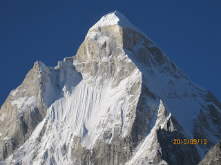
Kanchendzonga, as seen from Lamune, on the Goecha La Trek
IntroductionThis trip was about 3 months in planning, and was aimed at a trek that is emerging as one of the most popular routes in Sikkim: The Goecha La Trek (alternate spelling "Guicha La"). The route starts at the base town of Yuksom (5840 ft) in South West Sikkim, and climbs via Dzongri (13,300 ft) to Goecha La (16,200 ft), where one is within 5 km of the base of the enormous Kanchendzonga Massif (at 28,169 ft, the world's third highest peak) and even closer proximity to numerous other magnificent 7000m peaks. We planned to complete this trek over 8 days, from Nov 9 to 18, 2008, which would allow for a moderate pace. It would cover a round trip distance of about 90km. Ranjita and I had for company Prasad Naldurg and Rikin Gandhi, both experienced trekkers with very contrasting styles. We were taken care of by a very capable support team of Yangdin Subba, Buddha Bir, Shambhu, Sam Naam, and Ning Ma, all based out of Yuksom, a team assembled with the help of Mr B.S. Subba, Yuksom's Tourism Dept official.

Himalayan Peaks Viewed on the Goecha La Trek:
- Kanchendzonga (28,169 ft)
- Kabru (24,318 ft)
- Talung (24,251 ft)
- Mt Simvo (22,346)
- Mt Pandim (21,952 ft)
- Rathong (21,916 ft)
- Kabru Black Dome (21,780 ft)
- Tingchen Khang (19,833 ft)
- Jopuno (19,156 ft)
- Narsingh (19,111 ft)
Photo Albums:
- Day 1: Yuksom (5,840 ft) to Sachen, 8 km, moderate
- Day 2: Sachen (7,860 ft) to Tsokha, 8 km moderate
- Day 3: Tsokha (10,000 ft) to Dzongri, 10 km, strenuous
- Day 4: Dzongri (13,300 ft) to Dzongri La to Thangsing , 10 km, strenuous
- Day 5: Thangsing (13,000 ft) to Samiti Lake (14,500 ft) to Lamune 6 km, easy
- Day 6: Lamune (14,000 ft) to GL Viewpoint 1 (15,300 ft) to Kokchurang, 11 km, strenous
- Day 7: Kokchurang (12,500 ft) to Sachen, 21 km, strenuous
- Day 8: Sachen (7,590 ft) to Yuksom, 8 km, easy
Day-by-Day Trip Report:
Sat, Nov 8: NJP to Yuksom (Jeep)
Arrived NJP around 7:30 am after an eventless ride from Calcutta via Darjeeling Mail. Got stunning early morning views of Kanchenjunga right from the train: 100 km away, and floating miles up in the sky. An auspicious start.
We hired a super-enthusiastic Sikkimese driver Ajay, and made it to Yuksom after a short stop at Teesta bazaar (and a detour thanks to a road destroyed by landslides) by early afternoon. We met up with Mr B.S. Subba at Yuksom who arranged for us a guide (Yangdin), cook (Sam Naam) and other helpers. We did 8 days and Rs 5000 worth of groceries. Spent a chilly night in what might actually be the worst hotel we've ever stayed in (Hotel Kanchendzonga). Hot water was harder to come by at this hotel than on the trek, and the bathrooms rivalled the ones you find in engineering hostels.
Sun, Nov 9: Yuksom - Sachen (8 km, ~2000 ft gain, 3-4 hours)
Brilliant morning. Permits from the Tourist Dept (thanks to efficient Mr Subba), and the Police Dept (thanks to some superwoman that Prasad met there) were in place by 9 am. The trek started (trumpet call) at 9:45 with light daypacks while dYangdin stayed back to load the mules with groceries and heavier backpacks. (Note for next time: factor in mules when packing, so reduce bag count, not necessarily bag weight).
The initial hike out of Yuksom is through a deep valley carved by the Rathong river, which originates at the Rathong Glacier, which slides down (surprise surprise) from Rathong (21,916 ft) to the north-northwest. The Rathong Glacier also fuels the Rangeet, a lifeline of West Sikkim. The trail swings around spurs, climbs up away from the river through dense mixed jungle, and then plummets back into the river gorge, crossing the river several times, over picturesque, but nerve-tingling hanging bridges. We received reports, that varied slightly on the details, of two people (including a guide from Darjeeling) who fell to their deaths the week before at the second bridge.

Three hours later, we arrived at Sachen, a small clearing to the right and above the trail, and a trekkers hut to its left and below. Lunch was "wai-wai noodles" (no Maggi was to be had for ready money at Yuksom) and aloo puri. It took only a few cups of tea for the sun to sink behind the hills, at 2 pm. We debated the artisitic merits of various national anthems for a while, and then prepared for the night. As usual, assembling Prasad's tent took a significant effort from everyone, i.e. everyone except Prasad, who stood around giving directions, instruction manual in hand. Okay, okay, he had a bad back. The evening and night, for the last time on the trek, were moderate: the lowest temperature we saw was only 9 deg C, thanks to the protected surroundings.
Mon, Nov 10: Sachen - Tsokha (8 km, 2500 ft gain, 4 hours)
Lazy morning, breakfasted on porridge and omelettes. We slept a cool 10 hours, slowly realizing that this would be the norm for the coming week. We hit the trail at 8:30 am and initially continued the hike through similar surroundings as the previous day. A very steep descent to the river, during which we met a bunch of trekkers returning from "successful" Goecha La attempts. An Austrian pair of girls, and two middle-aged Indian couples were successful in getting to the first viewpoint, but none made it further due to icy conditions and lack of gear.
The scenery opened up as we ascended to Bakhim, and we received expansive views of the Rathong Valley. We took a break at Bakhim where we bought a bottle of coke for Rs 50, and some biscuits. From there on it was a steep climb to Tsokha. Minutes before arriving at Tsokha, a dramatic left turn on a ridge brought into view the High Himalaya for our first snow views on the trail: Pandim (22,952 ft), Tingchen Khang (19,833 ft) and Jopuno (19,156 ft).
Tsokha is a charming Tibetan village laced with the underlying tragedy of humans displaced by the games nation-states play. No more than a 100 Tibetans live dislocated, perched on an exposed hillside overlooked by Pandim and its neighbours. One of the Tibetans turned out to speak fluent Kannada! There are a few trinket shops that also sell you lemon tea, a monastery (which was closed), and a reasonably clean trekker's hut. The first evening above 10,000 ft slipped by with some failed star-gazing attempts (the moon was too bright), dinner, and some reading. It was a colder night, being higher, and more exposed.

Tue, Nov 11: Tsokha - Dzongri (11 km, 3300 ft gain, 5 hours)
Up by 6 am. Suprisingly warm morning (~12 deg C). Several cups of hot tea, cornflakes and pancakes later , we hit dirt at 8 am, and start a slow climb almost vertically up from Tsokha. Initially Tsokha remains in the view below, and then disappears as you climb through dense rhododendron forests, leaving the lower altitude taller mixed jungle below. Progress was slow for most of us (read 3 out of 4), likely due to the altitude kicking in. After a couple of hours we reached Phethang, a bald exposed meadow at the top of the mountain, with dramatic views to the Rathong Valley to the south, the famous Singalila Ridge to the West and Pandim and its neighbours to the North and West.
From Phethang a trail heads NW towards Dzongri and North towards Kokchurang. We took the first, and climbed higher to Deorali Dar ("The Meeting Place of Man and Mountain") the first viewpoint that in theory, provides the first unhindered views of Kanchendzonga. Sadly, we were denied a sighting by cloud cover, and satisfied ourselves with views of the other snow peaks mentioned earlier, as well as new sightings of Rathong (21,909 ft) and Kokling Khang to the west, and the Prek Chu drainage to the east. From Deorali, which we estimated to be about 14,000 ft, it was an easy, snow-littered descent to Dzongri, at 13,400 ft.
Rikin finished this hike in 3 hours, it took us about 5. Cabbage Soup (made from local cabbages bought at Tsokha), macaroni, and cauliflower were ready when we reached. By now we were all feeling the effects of altitude, having breached the 14,000 mark for the first time. We braced for a cold night and prepared for an early morning start the next day. It was a small, cosy hut, but in an oxygen deprived state, I realized that Pamuk's "My Name is Red" was notoriously difficult to make sense of.
We watched a great sunset as it sunk behind the Singalila Ridge into Nepal. Scattered clouds hung over various peaks, though nothing threatening. We met with "Mr Maldives" who splintered from his two American companions, one of whom got struck down by altitude, and a couple of fiesty Swiss girls. Mr Maldives (who's really from Darjeeling - he just works in the island nation) pointed his home town out from among the shimmering cascade of high ridges near the southern horizon. The temperature plummeted after sunset; post dinner (rice, daal and momos) and a game of 29, we hit the sack at 8 pm.
Wed, Nov 12: Dzongri - Dzongri La Viewpoint - Thangsing (4 hours, net loss, 300 ft)
4 am start. Icy surface at -4 deg C. Windchill made it worse. Much worse. Steep climb with headlamps in the dark. Good thing, since we had no idea how sheer the drop offs to the left were. Prasad stayed in to catch some sleep after a troubled night. 45 minutes later we were on the windy, exposed viewpoint, in time for a magical sunrise over a 360 degree panorama, starting from the Singalila Ridge in the west, Rathong, Kabru, Kabru Dome and Kanchedzonga directly in front, and Simvo, Pandim, Jopuno, Narsingh, and many other unknown peaks to the east. Colors rolled through a sequence of mysterious silver, pink, orange, gold, and finally, brilliant white. As the wind picked up, we beat a hasty retreat from the inhospitable mountain top, scrambling down through oddly colder temperatures as the sun rose.
After a quick porridge and omelette breakfast back at the hut, we embarked on the most scenic 2-3 hours of hiking of the trek. Bright sunny skies, expansive meadows, gentle downhill slopes, massive views of Pandim range as we inched closer to its base, the Prek Chu Valley, and grazing wild yaks. Happiness was short lived, as we plumetted with little advance warning through dense rhododendron forest for about 1500 ft with excruciating knee pressure, all the way down to the Prek Chu river bed at Kokchurang. After this, the trail slowly climbed to regain lost altitude on the other side of the river, but our speed was slowed by our tired knees.
We finally arrived at Thangsing (13,000 ft) @ 12 pm --- a grand location on a windswept meadow next to the Prek Chu, cradled by the now massive walls of Pandim, and Tingchen Khang. The location offers partial views of the Kanchendzonga Massif straight ahead to the north, a dramatic near vertical rock face climbing about 5000 ft on the west, and of course, Pandim rising 10,000 ft above to the immediate right (east). Dense fog rolled in in the afternoon, reducing visibility to 10 m at times, and sending the mercury down to just 7 deg C at 2 pm. We busied ourselves cleaning up the filthy hut (lead by Prasad), and pitching our tents in the hut for extra warmth (also Prasad's idea, a good call). Later we walked north past Jamling Tenzing Norgay's (yes, it's *his* son, a famous mountaineer in his own right, though) fancy campsite, to win ourselves ethereal views of a floating Pandim and Tingchen Khang at sunset. A senior American couple walked past us smiling, with hands on their hearts, touched by the momentary, gentle, yet awesome beauty of the scene.

Thu, Nov 13: Thangsing - Lamune - Samiti Lake - Lamune (4 hours, net gain ~700 ft)
Woke at 6:30 am, and scooted out for some sunrise views. Caught the last spill of orange before brilliance took over. It was to be a short day, so we took it easy. Left camp at 10 am, ambled over to Lamune, 2 hours north @ 13,741 ft, a more exposed but more dramatic location than Thangsing, with Kanchendzonga now in our faces. We continued hiking under Pandim and Tenzing Khang --- the proximity and new perspectives making them almost unrecognizable. We met returning trekkers and received mixed feeedback about the worth of attempting the actual pass. Apparently difficulty levels were high due to ice, but the views according to some were definitely superior at the "second viewpoint". Mr Maldives and a couple of Europeans reported success, but a couple of American women (one of whom looked extremely capable) did not. We did the flat then steep, windy hike up to Samiti Lake (14,200 ft), and were rewarded by a glacial lake in a spiritual setting, bluer than the sky, hemmed in on all sides by scree and sheer slopes, guarded by prayer flags. We also received a preview of the slope we would have to ascend the next morning on the far side of the lake (directly behind Prasad in the picture below).

We were back at cold, windy Lamune at 1:30 pm with splitting headaches, numb extremities, and a quickly fading sun. By 4 pm it was quite dark and 0 deg C. There was no hanging around outside the tents this evening. We slept in fits and starts, some not at all. Ranjita made good use of active warmers as the temperature continued to slide below zero. At 6:30, after dinner, at -4 deg C, we decided to turn in, in preparation for a 3 am start. The wind continued to buffet the tent at what must have been 30 mph all through the night. Luckily we had good soil to stake the tents down. Aside: Turns out Lamune is the base camp for Tingchen Khang. We saw some hikers heading up the trail, but couldn't make out if they were en route to a serious summit attempt.
Fri, Nov 14: Lamune - Goecha La Viewpoint - Kokchurang (7 hours, net loss 1000 ft)
The cold, cold night ended at 2 am for me, after which I could not sleep. It was -6 deg C, ignoring the wind. It took until 3:30 am to round everyone up, and we finally hit dirt (ice, actually) at 4 am, with the rapidly setting full moon keeping us company. We tramped through frozen streams, single file, counting flashlight pinpricks to account for each other, deathly quiet, except for the sound of ice cracking under our feet. We recevied ghostly moonlit views of Pandim, Tingchen Khang and Kanchedzonga en route. We passed Samiti Lake and started the slow climb through the scree, as twilight picked up and headlamps were turned off. Post 15,000 ft, the going was painstakingly slow. 30 min later, the first sunrise rays hit Kabru, Pandim and Kanchendzonga, which were now suddenly upon us. We arrived at the prayer flag strewn Goecha La viewpoint 1 (my estimate, 15,300 ft) to be greeted by more snow and a 40+ mph wind, a harsh, bitterly cold welcome that was fortunately compensated by the sub 5 km proximity to incredible Himalayan peaks. We were hemmed in by the twin peaks of Pandim, Tingchen Khang from a completely different angle, Kabru, which from here looks like a multitude of peaks, Talung, and of course, the massive Kanchendzonga, which as usual is gigantic, but from this perspective is strangely unfamiliar. The thrill is shortlived thanks to the outright torture at having to stand in one place. Quick pictures are taken of glaciers, rockfalls, ice formations. Not a leaf grows here. I tried half-heartedly to figure out the onward route, but Yangdin's equally half hearted response killed any inclination we had to try and make forward progress. After about 20 min of being buffeted around by the freezing wind, we headed back, through a gradually brightening Samiti Lake, to Lamune for breakfast.


We stopped at Thangsing for a ring-side view of a botched Yak Hunt in the company of the friendly mountaineer Jamling Tenzing Sherpa, who happened also to lose his fanciest tent (an Octahedron Dinner Tent from Mountain Hardware) to the winds at Lamune minutes before we arrived there. The Yak Hunt failed thanks to a rope tear. "No Yak for you", Soup-Nazi style. We arrived at Kokchurang at 12:30 pm, in the warmer bed of pine trees and rhododendrons, now wondering if we should have pushed for going further beyond viewpoint one.

Sat, Nov 15: Kokchurang - Sachen (21 km, 4000 ft loss, 7 hours)
Headed out at 7 am, after spending the previous evening playing Poker and 29. We hiked out along the (shorter) Prek Chu route, avoiding the climb to Dzongri (which the mules had to do). The trail is narrow but gorgeous, running through virgin jungle for a couple of hours, later turning interesting (read tricky) thanks to landslides, fallen trees and icy mud streams. The trail swings up and down the eastern flank of the river before climbing high to Phethang. Here around 10 am we joined up with the inward route, and met up with the mule caravan that had meanwhile arrived via Dzongri. Another 2 hours of steep descent and walking along log-paved ridges later, we reached Tsokha, where we stopped for lunch around 12 pm, and savored our last snow views. Lunch was quick and awesome: soup, fried potatoes, macaroni. Quick march after lunch, and Prasad promptly took off down a short cut, Captain Haddock-style, sparking consternation from Ranjita and me, and later, once he had regained the main trail, downright fury from Yangdin. We quickly sunk to the Rathong Valley, and crossed the first of 4 bridges. Probably too quickly, because certain knees and feet ended up with minor injuries. Arrived Sachen 3 pm, and used the filthy hut instead of pitching tent (my "cologne" turned out to be body wash, so that didn't help). The hut was so filthy that a spot outside littered with mule dung seemed clean by comparison, so that's where we spent the afternoon.
We met several uphill trekkers during the day: a Japanese father and son duo, the Alaskan couple from the Darjeeling Mail, a Swiss guy who was leading a trash removal operation on the trail. Looked like the season was over as far as Indians were concerned.
We lost 4000 ft in 21 km today. A good day's work.
Sun, Nov 16: Sachen - Yuksom - Kurseong
6 am rise and shine, hit dirt at 7:15. Three hours, three bridge crossings, and many stream crossings later, we reached Yuksom at 10:00 am. Post trek formalities and niceties were conducted with Yangdin and co. (which included Mr Spaced Out, which oddly, seemed to know his facts) and of course Mr B.S. Subba. Ajay landed up with his Chevvy as planned, and soon we were hurtling down the mountains towards Jorethang. A last minute change in plans made us head to Kurseong via Darjeeling to spend the night. The tea garden route from Jorethang was spectacular, but super dangerous. The SUV (a stupid RWD Chevvy) got stuck on a ridge soon into the drive, with the front left wheel hanging over a 30 ft drop, and the remaining three mired in mud. 30 minutes of mud-splattering and ridge-hacking later we managed to free the car with help from locals. The effort was worthwhile as we were soon rewarded with fabulous views of Pandim, Kanchendzonga, Kabru, and Kumbhkarna, Koktang, (which we mistakenly celebrated to be Everest, Lhotse, and Nuptse). We drove on through "Gorkhaland" and had brief encounters with Darjeeling's Toy Train, the region's famed obsession with Rock music, and beautiful tea estates. Stopped at Sonada where Rikin bought a snack called "Lapsi Sweet" from Nepal, which is labeled, with complete frankness, "Not Yet Found in Other Countries". Arrived to a warm welcome at Mashi's place in Kurseong (12 years since my last visit), hot baths, a superb meal (with tree tomato chutney, freshly picked guava, and isqus root), and real beds and blankets. Bid goodbye to Ajay, great guy, excellent driver.

Tomorrow morning we will head down to Bagdogra and return to the real world, leaving paradise behind, but imprinted indelibly on our consciousness.
Post-trip Random Thoughts:
While the feeling of regret at not having made progress beyond the first viewpoint was high on the concerned day, now, with hindsight, the feeling has diminished considerably. Harsh conditions are the risk one takes by attempting this trail so late in the season. It's a fine balance though, since earlier in the season, the risk of cloud cover and precipitation is higher. April may be an interesting time to do this trek, since the rhododendrons will be in bloom.
We conclude that 8 days is certainly a padded itinerary. My personal opinion is that one could quite easily accomplish this trek in 7, and perhaps even 6 days (if one is ready to forgo the Dzongri detour in the interest of focusing on the pass area and beyond). However, one thing to keep in mind is that supplies (mules/yaks) cannot take the Phetang - Kokchurang shortcut. It's worth planning for 6 or 7, but budgeting for 8 all the same to allow for flexibility in the plans.
Finally, this is pristine country of which sadly, the subcontinent has precious little left. To paraphrase Edmund Hillary, no one conquers these mountains, we conquer ourselves to experience them. They merely stand silently and allow us passage. Tread softly on these trails and give them your respect.
Resources:
- India Mike Trekking & Mountaineering Forum
- Supratim's Blog
- Mr Srinivasan's Travel Blog
- Harish Kapadia's "Trekking and Climbing in the Indian Himalaya" (difficult to find book)
Comments
- Our black dog friend who I thought of as "Nemesis" who followed us up to the pass and back, and kept us company almost from Dzongri until Thangsing.
- Innovative use of maida. Honestly, I've never had it taste so different in so many different ways.
- Being shouted at by the elderly Japanese tourist, who wanted (to rent) my walking sticks and would not believe they were mine.
- The shortcut: It was a stupid thing to do, but it was very well used, and I could hear yak bells where I left the others. Nevertheless, Yangden was mad because it was more dangerous than the main trail and I am suitably contrite, even ashamed..
- Mr. Gupta's panneer.
- The filthy hut at Sachen. I directly attribute all our post-trek health issues to the night we spent there.
Tour package to sikkim
Kailash Mansarover Yatra