Har-Ki-Dun Trail Run
 |
| Swargarohini peaks from Har Ki Dun |
Since the last 2 years, I've been pursuing trail running
as an endurance activity in the company of Santhosh Padmanabhan (Chief Coach at RunnersHigh), and for a large part, Rajeev Muralidhar. It all started in late 2011,
when the three of us decided to participate in an organized event, the
Annapurna 50K, on Jan 1, 2012. We trained for a few months, and in the end, all
three of us completed an exhilarating race, but with complaining muscles, and
immense fatigue at the end of it. That experience taught us to approach
mountain trail running more thoughtfully and systematically, focusing on
strength training, and long runs on tough terrain, to complement the usual training regimen of long distance
running. Since then, we’ve run hundreds of miles of trails in varied
conditions: in hot hilly terrain around Bangalore and the Western Ghats, and in
the high mountains of Uttarakhand (Gaumukh-Tapovan, Dodital-Darwa Top), and
West Bengal (Sandakphu-Darjeeling).
We originally hoped to plan this trip around a single day, 24
hour run. Several other runners within Runners High were training for long
distances at the Bangalore Ultra, so Santhosh designed a convenient schedule
that all of us could follow, with slight variations tuned to individual goals.
We even gave ourselves a name – the pack of "Jobless, Long, Boring Runners" which
included amazing people like Chandra, Mani, SriniP, Kaiwan, Navin, Vinay, Abhi, Asad, Rajeev, and of course, Santhosh. A few months into the program though, I had to
abandon the idea of a 24 hour run due to a freak back injury, which robbed me of a few weeks of training and due to various other constraints, the set of runners ready for a Himalayan adventure reduced to three - Asad, Santhosh, and myself. It was also proving hard to find a Himalayan trekking route that permits night-time movement. In the end, we decided the mountain trail runners would do a 12
hour (sunrise to sunset) run, and a 6 hour run, on back to back days.
Choosing the route was tricky. We needed a route that was only moderate in terms of altitude, since we would have limited time for acclimatization. So we set 12000 ft as a limit. Also the route needed to provide support en route for meals, have good mountain views, be obvious enough not to need
a guide, and be accessible within a day from a train station or airport. Santhosh, Rajeev and I had just run in the Sandakphu/Darjeeling area a few months ago. Though it met all the
requirements, going back wasn’t an attractive proposition. Milam glacier looked enticing,
but altitude and access time were concerns. We finally we settled on the
Har-Ki-Dun and Ruinsara Tal valleys.
Research showed the route to Ruinsara Tal is unclear at places, so the plan was
to limit ourselves to the former, and squeeze out a 12h/50-60K day from it.
 |
| The route to Har-Ki-Dun follows the Tons River, a tributary of the Yamuna |
The Har-Ki-Dun and Ruinsara valleys form part of the Yamuna watershed, and are
located in the North Western corner of Uttarakhand. Though physically close to the Gangotri area, to reach the
Bhagirathi valley on foot requires an west-to-east trek across first, the 16,000 ft high Bali Pass which separates the Ruinsara and Yamuna valleys, and then the 14,000 ft high Darwa Top which separates
the Yamuna and Bhagirathi valleys. Imaginably, this would be a spectacular trek, cutting through the Banderpoonch range
of peaks. From Har-Ki-Dun another route takes you north, across Bhorasu Pass (17,000 ft) into Himachal Pradesh.
Getting there
The trailhead for Har-Ki-Dun is at Sankhri, a lovely village
perched at nearly 7000 ft, about 200 km north-west of Dehra Dun. It’s a long
road trip to get there. We had a pre-booked Indigo take us to Purola (5 hours), followed by a shared jeep from Purola to Mori - where 18 of
us suffered the “Great Himalayan Squeeze” in a Mahindra Max (2 hours) - and finally a ride on a rickety bus that had likely never
seen a set of shock absorbers from Mori to Sankhri (1.5 hours) . We reached Sankhri a little before 5, where the
GMVN caretaker was expecting us. He set us up with hot water, rooms with clean
blankets and linen, and functioning toilets (no such luxuries were available higher up on the trail). Dinner was at the dhaba across the lodge. Very quickly we settled
into the mountain diet of parathas for breakfast, and aloo sabji-roti and
dal-chawal for all other meals embellished with eggs wherever possible.
 |
| Sankhri, 6600 ft |
Sankhri to Taluka
Next morning we made a late start (nearly 9 am), knowing we would only brisk walk (no running) from Sankhri (6600 ft) to Taluka (7000 ft) and take it easy the rest of the day; at this point the plan was to run from Taluka to Har-Ki-Dun to Taluka within 12 hours on the following day. On hindsight, this is where we could have exercised better judgment, but more on that later.The 12k from Sankhri to Taluka is actually motorable, except when landslides make it not so. Currently it’s open to traffic – just one jeep every hour, so it was hardly a bother. The dirt road is mostly flat, and except a couple of stream crossings, there’s nothing challenging about it. We hiked at a good pace through the dense pine forest, disturbing a giant family of langurs in the process. We picked up a canine companion who would keep us company for the next three days. At the bottom of a landslide, we spotted a large group of vultures grouped around what we guessed was some animal remains but we couldn't make out what it was. At one point, we met a group of women carrying huge bundles of grass, and Santhosh gave it a try to discover that each of them were probably carrying 20 kilos worth! They giggled themselves to death, and asked us for “topee”. Confused for a second, we realized they were asking for “toffee”. I doubt the Halls orange-flavored mouth fresheners were their idea of a treat, but that’s what they got.
We reached Taluka a little before 11, and settled into the grimy GMVN lodge
that’s slated for demolition once a new set of cottages are completed. Why that
means the rajais and sheets should be stained and filthy was unclear but it probably had
something to do with Mr Ramesh the caretaker, who demonstrated a keen fondness
for organic leafy intoxicants.
We spent the afternoon taking a short hike down the Har-Ki-Dun trail, chatting with a local kid who was returning from boarding
school in Purola for the Diwali break, and with a few women who were de-husking
a cereal that looked like a millet. Other than that and rajma, not much else grows in these valleys due to a lack of irrigation infrastructure. I took some photos of one of them with her daughter, and rashly, promised to mail her the prints. I got stumped when she wasn’t able
to give us an address. Later at the lodge, we did a set of exercises that
Chandra had prescribed for pre-run day that Vinod dutifully photographed. The last task of the day was to carefully separate some of our gear to lighten our packs for the next day’s run, but ensure we had enough in case we decided to end the run at Seema, higher up in the
valley. A few rounds of rummy later, we were asleep under the filthy blankets.
 |
| Village women of Taluka dehusking a millet grain |
Taluka to Har-Ki-Dun to Seema
Next morning we left Taluka at 4:30 am and plunged into the darkness, headlamps bobbing up and down on the undulating, rocky trail as it gradually ascended a deep narrow valley. The roaring Tons was to our left and below us, and a forested mountain slope rose steeply to the right. From the start I felt lethargic; my body refusing to warm up in the cold of the night. Very quickly one pair of headlamps (Santhosh and Vinod) shot ahead and got lost to the dark. Asad was ahead of me, and even though he shared my concerns about whether Santhosh was on the right route or not, he was moving efficiently. When one or two forks appeared on the trail I got irritated that Santhosh did not stop to make sure everyone took the same direction. Overall, it was a miserable start to the run for me, and I was looking for all kinds of excuses not to run. A pre-dawn grey gradually arrived, which did nothing to lift my spirits, or pace, and I finally caught up with the group while they were taking a break. We discussed concerns regarding the route. I was worried that we hadn’t come across the village of Dhatmir, which Harish Kapadia's write up claimed we would. We decided to push on since the direction was right and likely the other routes we had seen would have taken us through it. Finally to my relief, the trail started to gain elevation rapidly. We saw the village of Gangar on the opposite bank of the river, which looked quite desolate from where we were, and what seemed like ages later, we spotted Osla, also on the opposite bank. Minutes after that we arrived at Seema.
Seema consists
of nothing but a Forest Rest House (freshly painted and attractive), the GMVN lodge (a dump almost
as bad as the one at Taluka) and a dhaba run by one Jowar Singh from Osla. A guide who we met at the dhaba (employed by IndiaHikes, a Bangalore based trekking company)
dissuaded us from venturing into the Ruinsara Tal valley without support, but
okayed our plan to go to Har-Ki-Dun and back. He gave us pointers for local routes in
Har-Ki-Dun to Mironda Tal and the Jaundhar glacier, but was skeptical about our
chances of doing all of that and returning to Seema, let alone Taluka, in one day. So we
decided to listen to his advice: we would explore other routes to
the extent possible based on a turn-around time, and return to Seema for the
night.
With parathas in our packs and maggi in our insides, Asad, Santhosh and I started out a little after 9 am, jettisoning some more gear for Vinod to babysit. He would remain
in Seema for the day. The sun was fully out now, and it had turned into a
beautiful morning. We crossed a bridge and steeply climbed out of
the river bed, up and out of the dense forest to reach the eastern end of the village of Osla. A bunch of grass-bundle carrying girls showed us the way, and received some
paracetamol tablets in return, to aid "bhaiya" who was suffering from "bukhar". From
here the views opened up significantly – the winding Tons valley lay behind and at least a 1000 ft below us, and meadows and glittering snow peaks lay ahead. I felt something
fundamentally change in my attitude – maybe it was the food, or the sun and the
views. I felt strong, and started moving well for the first time, eagerly
approaching the uphills, and running the downhills with enthusiasm.
 |
| Tons River at Seema |
For the next hour or so the
run was blissful – the trail skirted the spurs, moving up the valley, gradually gaining elevation,
reducing the river to a silver trickle far below us. Occasionally we would swing into a side
valley to cross a stream on some logs and then swing back out into the main
valley where the views of the Banderpoonch range above the Ruinsara Valley were
now clear. On one of these crossings, we regrouped, looked at a fork in the
trail, and picked one that seemed to make sense. Within 5 minutes I looked
around and realized that we had possibly made a mistake, but there was nothing
to be done – Santhosh was already out of sight and earshot.
The trail remained
spectacular, so I banished these thoughts and powered away admiring the views
of the Ruinsara valley. At some point I told Asad that I was expecting the
trail to swing to the left. I was concerned that that wasn’t
happening, and sure enough, about 45 min later, we learnt from some local
shepherds we were off the Har-Ki-Dun route. At this point I was still energetic, so I
gladly attacked the solution that the shepherds threw at us, which was to climb
the steep scrub slope on our left, reach its crest, and rejoin the correct trail.
 |
| Kalanag (left) and Banderpoonch (twin peaks) |
Easier said than done – the slope was steep, and covered
with dry bush. Occasionally on all fours, we climbed scratchily upwards for about 40
min, our doubtfulness regarding the shepherd’s guidance increasing
with every step. We were likely above 10000 ft at this point, so even though I
wasn’t paying attention, I must have been breathing pretty hard. Asad and I had to stop several times, even
when we knew we were close to the trail - Santhosh had reached it 10 min before
us and kept pushing us to keep moving.
Being back on the trail was a relief, but I had lost my earlier rhythm. The landscape changed back into pine forests, and after some elevation gain, even though a long downhill stretch presented itself, I
could barely bring myself to run it. Asad was slow too, so the two of us stuck together and kept moving steadily. A 5
minute snack break at a stream crossing helped, and we ploughed on, wondering
where the heck Santhosh had got to, and why the 12k trail was feeling like 20.
I seriously started to question if we were on the wrong trail again and
discussed next steps with Asad. We decided to keep going for another 10-15 min,
and I blew on my whistle a few times hoping to elicit a response from Santhosh.
Oddly enough, I got one, and energized, we moved on. Ten minutes later, we spotted
the Forest Rest House in the distance, and what appeared to be Santhosh loitering on the porch. It
was him, but not only was he too far away for either of us to hear each other's whistling, he didn’t
actually have one! So I have no idea what really happened there.
Asad and I finally reached the rest house at 1:30, a good
hour behind Santhosh and 4.5 hours from Seema.
Of course, we likely lost about an hour due to the earlier mistake, but all the
same, it was slow moving, almost certainly attributable to the altitude. We had some tea at the rest house, and ate our parathas.
Even though I didn’t have a headache, I mentally checked off other all too
familiar symptoms - lethargy, yawning, lack of appetite, high pulse rate, and
lack of motivation. I decided to stay put, and not gain any more elevation. I
would take in the scenery while Asad and Santhosh made an attempt to hike
towards Mironda Tal.
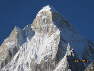
 |
| Peaks of Har Ki Dun |
Har-Ki-Dun is gorgeous. In its lower parts
(through which we came) it’s covered with lush pine forests and bhoj trees.
Higher up it opens into a meadow and even further up, splits into two valleys.
Directly east lies the route to Bhorasu Pass (17,800 ft) via Mironda Tal which
leads to Chitkul in Himachal Pradesh. Not much can be seen of this route from
the rest house as the trail climbs steeply right at the outset but we heard the
views are remarkable in this direction. Slightly to the south lies the other fork
of the valley – more desolate, but cradling the headwaters of the Tons river. You
can see the fledgling river in the distance as it snakes its way through the
terminal moraine of the Jaundhar glacier, past the base of the Swargarohini
peaks into a blue raging torrent as it plunges through the pine forest below.
The glacier itself is at least 5k away (10, according to the guide we met at Seema). It looks
like the debris-strewn body of ice, typical of Himalayan glaciers. If better
acclimatized, running out to the glacier and back would make for several hours
of engaging trail running. But with our current level of acclimatization, the fast
approaching cut off time, it was of course out of the question.
 |
| Santhosh at Har Ki Dun |
 |
| Asad and Kanishka at Har Ki Dun |
The Swargarohini peaks were crowned by clouds at the time of
our visit, but it was clear that even if not high by Himalayan standards, they require technical mixed ice and rock
climbing; which suggests that Yudhishtira and his dog clearly had the necessary
skills while clearly the others didn’t!
|
| Swargarohini peaks: the pandava's last journey |
 |
| Har-ki-Dun river in the afternoon sun |
Santosh and Asad wisely thought the better of going out to
Mironda Tal, and were soon scampering back to the rest house. We hung around
for a few minutes and finally set off on a trot at 2:30 pm. The little break
had done me good, and as we lost elevation, I felt strength returning, and started
to enjoy running the same trails that seemed so excruciating on the way up.
Behind us ominous clouds had started to build up, and some flurries started to
come down. But ahead, to the west, the valley was swathed in a warm but mellow
afternoon sun with the Tons glittering as it snaked away from us. All three of
us ran well, and without making any mistakes on the way, reached Seema a little
after 5 pm, completing the return journey in 2:45. All in all, in 12.5 hours we covered
about 45K, somewhat lower than planned. Left to himself, Santhosh would have probably covered more. On
hindsight, we could have planned it better by acclimatizing one night in Seema,
and then doing the long run starting and ending in Seema, including side
trips to the lake and glacier. In any case, mileage was an intent not a
goal for this trip, so none of this was a big deal for any of us really.
 |
| Shepherd near Osla at sunset. |

Comments
Your narration of the encounters felt real!
Thanks for sharing this.
Dilshad