Chopta
This trip was a first in a couple of respects. We had
traveled to the Himalayas before with Ishan (Kashmir 2015, and Kumaon, 2016)
but this was the first time we would be camping with him (he was all of 2.5
years old). I was also looking forward to doing some hiking in the mountains, and
learning how my body responds to high altitude after the changes it went through a few years ago.
We chose Chopta in the Garwhal region for several reasons.
Being part of the Kedarnath Musk Deer Sanctuary, it has not fallen prey to the
devastation that unplanned development has wrecked across the region. Second,
there are several managed campsites in the area which save you the hassles of dealing
with your own sleeping bags, tents and meals. The camps are pretty basic, as
they should be, but provide enough creature comforts to make it possible to enjoy
the mountains with kids. The meadows of Chopta proved to be a great location that
allowed for lazy, scenic days at the camp, as well as hikes of varying levels
of difficulty.
 |
| Our campsite at Chopta had great views of the Kedar group of peaks |
Getting there
It was pretty chaotic at Bangalore airport in the early
hours of Oct 7, where holiday travelers and harassed Indigo personnel were going
at each other at the check-in counters. Luckily we had no issues, and the three
of us, Santhosh, Laxmi, SriniP and Neel made it to the gate in time. This was the first
time we were flying all the way to Dehra Dun (with a change of planes in Delhi).
Congestion over IGI lived up to its reputation, and we circled for nearly 45
min before landing, making the connection to the Dehra Dun flight a little
tight for comfort. There were no views from the flight, and the dreaded haze
made me wonder if this was to be a repeat of our Kumaon trip in the Spring.
It was disappointing to see the characterless steel and glass
terminal at Dehra Dun (it’s official name is “Jolly Grant Airport”, after all),.
Thankfully we were the only flight on the tarmac, so it was less than 15
minutes from the aircraft seat to a hot parking lot loading our bags on the
roof of a brand new Maruti Ertiga driven by the able hands of Vinay.
Vinay is an entrepreneur based in Naini Tal, running
homestay, taxi and adventure sport businesses. We started from Jolly Grant at
about 1 pm, and drove through Rishikesh, Dev Prayag, Rudra Prayag, Kund,
Ukhimath, and reached the campsite, a few kilometres west of Chopta at 8:30 pm. On the way poor Ishan learnt that
being driven on twisty-turny mountain roads is not as much fun as it’s made out
to be.
The Pristine Peaks Ecocamp had limited electricity (based off solar panels and finicky associated circuitry), spacious and functional tents,
warm blankets, warm-water on demand for bathing, smoke flavored hot water
(prepared on a woodfire stove) for drinking, and a regular supply of staple
mountain food: paranthas or eggs for breakfast, roti, aloo subji and daal for
most meals, and lots of sweet milky tea. The location is perfect. It’s perched
on a meadow with pine forests above and below, and a view of the Kedarnath
peaks to the north and a sneak peak (literally) of Chaukhamba, all from 50 feet above the
campsite.
Deoria Tal
We learnt there are two ways to get to Deoria Tal, a common
tourist attraction in the area. Option 1) Drive to Sari village (about 20K back
in the direction along which we came) followed by a 2-3 km hike to the lake.
Option 2) take a “junglee raasta” a little above the campsite and hike 14 km of
rough trail to the lake. Our camp site manager did a good sell job on the second,
so Santhosh, Srini, Laxmi decided they would hike out, while Neel, Ishan,
Ranjita and I would drive. The plan was they would leave early, and we would
leave late so that we all reach the lake roughly around lunch time.
The hikers left early, but also got for company another
person who was sharing the campsite. Apart from slowing the group down
significantly, he also resulted in them getting separated (luckily at a point
where they had nearly reached the lake), leading to some confusion.
On the other side of the hill, Ranjita, Neel, Ishan and I
started inching our way up from Sari village. After the first 200m, Ishan started insisting on being carried. I tried for a bit but gave up soon after. Dealing
with my own breathing challenges leaves no room for conversation, let alone
carrying an additional squirming 10 kg. No amount of coaxing would make him
walk. Ranjita said she’d try, and did amazing well. She took the lead, and made
steady progress carrying him, while Neel and I brought up the rear. I found the
going pretty hard (I was not mentally prepared for such a steep climb), and it
seemed to be much longer than the advertised 2 km. We reached the lake around
noon, and one by one started meeting folks from the other group.
 |
| Neel and Ishan at Deoria Tal (the green color is due to recent algae growth) |
Sadly, there were no views on offer. The lake was a dull
green due to recent algae growth. That late in the morning, it was no surprise
that Chaukhamba was obscured by clouds. Several noisy groups were camped near
the lake, but it was reasonably clear of trash.
Over lunch, on hindsight somewhat hastily, I decided to join
Santhosh and Srini for the 14km hike back, while Laxmi decided to join Ranjita,
Ishan and Neel on the short route back to Sari. We started at 2 pm, with a goal
of hitting the crest of the trail, a minor peak, by about 3 pm. We skirted around the lake, and started
climbing soon after. We fell into a rhythm where Santhosh and Srini led, and every 15-20 min or so would allow for me to catch up. It was all
going quite well, and we reached the summit shortly after 3 pm. All three of us
ran down from the summit quite fast and then the same routine set in during the
uphill sections.
 |
| This was after the summit, but before the downpour. We were all still smiling. |
Soon, the weather turned. First a light drizzle, then a full
blown thunderstorm with torrential rain and hail. The trail was reduced to a
swamp, and progress slowed considerably. Luckily we were prepared with rain
gear, so on we plodded for what seemed like an endless amount of time. I was
beginning to tire, for reasons I did not think through at the time. I
was so focused on the trail and keeping up with Santhosh and Srini, that I wasn’t
paying attention to hydration or nutrition. Also, the limited hours of daylight
we had was playing on my mind (even though we had headlamps). At this point I was grappling with all kinds of negative
thoughts about hiking in the dark.
In fading light, we reached a meadow where we met a
group that was camping. Hearing we had another 6 km to go was disheartening,
and I almost considered asking them if they could have me sleep over. Santhosh
and Srini realized I wasn’t doing well, and Srini decided to fall back and keep
pace behind me, while Santhosh focused on route finding through the dark.
Thankfully the rain had stopped, and the trail was less muddy. I told myself
that on no account would I sit, but allow myself only periodic standing rests of
a few breaths long. Sometimes these rest breaks would get longer and I would
imagine Srini behind me getting worried, which would get me moving again. At
one point we came to a section where the trail dived near vertically into a
gorge, and crossed a bridge at the base. Regrouping after the bridge, we
discussed how much further it is, and I refilled my water bottle. That's when
I realized I had not been drinking enough. I made a note to myself never again to hike without a hydration pack. I
was worried that the hike out of the gorge might be as steep as the descent we
just came down, and the arithmetic of what time we’d reach camp just wasn’t generating
any encouraging results. The repercussions of that kept playing through my
mind. Incredibly enough, the hike out of the gorge was easier than feared, and thanks to Santhosh’s
route-finding skills, we didn’t make any wrong turns. The skies had cleared,
and by the time we saw the full moon shining brightly over Chaukhamba, we were
just a kilometer from the trail head, where Vinay and his Ertiga were waiting
for us. It was 8:30 pm.
I reached camp, shivering from cold and exhaustion, and
couldn’t help berating myself for my rookie mistakes. Santhosh got me
electrolytes, and Ranjita’s concerned and reproachful looks made me have a
quiet chat with myself.
Tunganath and
Chandrashila
Armed with the wisdom of hindsight, two days later, I was at
the trailhead for Tunganath and Chandrashila at 5 am. I spend the previous day watching
Ishan at camp, while the others walked up to Tunganath. They decided to skip the hike to Chandrashila since
the clouds had rolled in, so I was all the more determined to make an early
start. I was alone, so that I had the freedom to set my own pace. I had food,
salt tablets, adequate water, most of which was unnecessary, given how busy the
trail is. Nevertheless, when I started in the pre-dawn darkness, I was nearly
alone on the route.
Tunganath is a thousand year old Shiva temple perched at a
little below the 13000 ft summit of Chandrashila, and is one of the Panch
Kedar, a group of Shiva temples in the region that have various legends
associated with them. Tunganath is the highest among them, but interestingly,
has the easiest access. The trail leading from Chopta to Tunganth is a 10 feet
wide, paved path, with occasional stalls selling tea and snacks. Even so it’s a
beautiful walk, especially if you start early to beat the crowds (which include
people and mules).

The trail gently climbs along the northside of the Chandrashila mountain,
rewarding you with brilliant views of the sunrise over the Chaukhamba peaks to
the east all the way to Banderpoonch and Draupadi Ka Danda to the west,
including the Kedar, Gangotri groups along the way.
It’s an easy hike by any standards, so I made steady
progress without any trouble. The rewards of an early morning start were a
group of Monal strutting about among some brush about half the way up. I reached
the Tunganath temple at 8, where I stopped for some maggi and tea at one of
several tea stalls. The temple was already quite busy and noisy with devotees
(who had likely stayed overnight).
 |
| Sunrise over Chaukhamba |
The paved trail ends at Tunganath, and a dirt path skirts
the temple on its right and takes you towards the summit of Chandrashila. Almost
immediately, the stalls disappear, the trail becomes rugged, and has fewer
people on it. It’s a lovely hike to Chandrashila, with vistas gradually opening
up to the north as you ascend. I reduced my speed as the altitude started to
kick in but it was never a bother. There was ice in several spots that early in
the morning, but the route while not marked, is impossible to miss. A final
crest led to the flat summit where the view to the east, though in the shadow
of the rising sun, was spectacular nonetheless. It was hard to pick out all the
peaks, but Nanda Devi and Trishul were relatively obvious. I was excited to
spot Changabang, a major peak in the Nanda Devi Sanctuary, a source of intense
debate on a trek to Kuari Pass 9 years ago! Folks on the summit claimed they
could see the Panchachuli group, but I wasn’t convinced. In addition, all the
peaks visible from Tunganath were also visible, producing a panorama of more
than 180 degrees, and several hundred kilometers of the Garwhal and Kumaon
Himalayas. Chandrashila at over 13000 ft, has high prominence, so the views in
all directions are pretty amazing.
 |
| Chaukhamba and Kedar range from the Chandrashila trail |
It was a quick hike back to Tunganath, where I took an
obligatory chai break, and chatted with a fellow Bengali whom we had met at our
campsite earlier. He (and his monkey cap) were staying at the local
Dharamshala. I was back at the Chopta taxi stand in about 60 min, where in the
company of a chatty uncle from Bangalore, I downed some coffee (which was
surprisingly good, considering where we were) and some aloo paratha. Folks had
suggested forgoing the jeep ride to camp in favor of a trail. So that’s what I
did. The trail starts out in a trash pile behind the gaggle of shops, then opens out into rolling meadows all the way back to our camp. I was back well in
time for lunch, finishing a satisfying morning in the mountains. Couldn’t be
further from the misery of two days prior. Ranjita and Santhosh repeated this exact hike the following day, to compensate for the bad weather day they experienced earlier.
 |
| Chopta meadows |
Madmaheshwar Trail
Run
The next day, Santhosh and Srini did a trail run out to Madmaheshwar
and back. Madmaheshwar is another among the group of temples known as the Panch
Kedar. The trek to Madmaheshwar is typically done over 3 to 4 days, and goes
through dense forest, and is somewhat off the beaten path compared to say
Tunganath or Kedarnath. It was a solid day’s running for Santhosh and SriniP, with
plenty of elevation change, and a total distance of about 40 km. Not
recommended for amateurs. That evening we met some people who had tried hiking
it and had abandoned the attempt. They were flabbergasted to know our folks had
completed the entire route in a single day.
Wrapup
We spend the last day driving around the Chopta area, and
visited a village called Makku, where the Tunganath deity spends the winter,
not before touring the local country for a week or so. From the Pristine campsite,
there’s a lovely walk through the forest to a sheep farm, where you get views
of a few more peaks and a terrific spot to enjoy the sunrise and sunset. Ishan
loved the hike, and walked the 2-3 km entirely on his own causing us more than
a few moments of nervousness on some of the trickier sections. On the drive
back to Dehra Dun, Ranjita and Laxmi brought all of us up to date with the
latest gossip from Bollywood. Other than one stop for breakfast near Srinagar,
we made good time and reached Jolly Grant well before noon.
 |
| Sunset point, a short hike away from the campsite |
 |
| Ishan's first complete hike |
 |
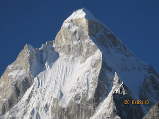
| Kedar peak from Chopta |
Ishan enjoyed the campsite a lot, and months later, fondly
recalls the “tent” and the “white mountains” and how cold it was. Night time
temperatures dipped to around 5 degrees, but the tents were well appointed with
beds and hypoallergenic blankets. He had a blocked nose on a few nights, so we
kept him on mild anti allergic drugs. Food was a bit of an issue
as well, since stuff doesn’t cook well at altitude. Eggs saved the day for many
of his meals. The only area he really struggled with was the inbound journey. He
had a mild fever the first night, cumulative effect of a 4 am start, two
flights, an 8 hour drive on tough roads, and unfamiliar meals. We told ourselves
that the next time we do something like this we’d break the journey up into two
days. On the way back he was fine. It was a 4 am start again, and he slept a
lot. We took a break at Dehra Dun, where we stopped at Ranjita’s
cousin Sandip and Rashmi’s place for an enjoyable 24 hours at the Air Force base.

Comments
Megana
madhuri.