Darma Valley and Panchachuli Base Camp
Darma Valley isn’t on any list of top 10 treks in the Himalayas, or for that matter, even Uttarakhand. Perhaps its remoteness explains it. Getting to its trail head takes over 24 hours of challenging travel from Delhi. Perhaps additionally, the proximity of the Kailash Mansoravar route draws attention away from it. Whatever be the reason, the lack of commercialization accompanied by pristine mountain scenery and unique local culture, makes Darma Valley a gem of the Kumaon region.
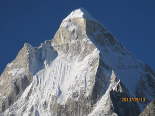
 |
| The highlight of Darma Valley is base camp for the Panchachuli group |
Darma Valley served for a long time as a major trade route with Tibet, but like the Milam Valley, this aspect of its economy was stopped in its tracks after the war with China in 1962. Happily, this has not affected the prosperity of the region. The local population, named “Rang” or colloquially (and more inaccurately), “Bhutias”, now typically split their time between the valley in the summer months, and mainstream India for the rest of the year. A major driver of the economy is Yarsagumba, a fungus whose host caterpillars are found in abundance in the meadows and forests of the valley. The market is almost entirely Chinese, accessed via middlemen based out of Dharchula (the nearest town) and Nepal.
 |
| Poor availability of good maps for the area results in the popularity of hand-drawn maps like this one |
The trip was a complex one, involving two groups, each one trekking the valley till Panchachuli Base Camp on successive weeks. At the center of this elaborate plan was Ishan, our 3 year old, who we decided, was not quite ready for a multi-day Himalayan trek. So on week 1, Ranjita went trekking with Shailesh, Kanchen, Rakesh (aka Mawa), Deepshikha, and their 7 year old daughter Sheen, while I spent the week traveling around Mukteshwar, Chaukori, and Didihat with my parents and Ishan. After her trek was over, Ranjita met me in Didihat, where I handed Ishan over to her. From there she, my parents and Ishan continued onto Munsiyari and Binsar, with a hazy notion that I may or may not catch up with them in Binsar, but would, in the worst case, see them at Kathgodam, since we were all on the same train back to Delhi.
May 14, Dharchula
I traveled from Didihat to Dharchula for Rs 200 in a shared taxi with hotly contested internal real estate. I actually paid for two seats to ensure the taxi left Didihat only one hour late. But that didn’t buy me any additional space, as we picked up passengers along the way. Near Didihat, we collected Laxman Singh, who was to be our guide for the trek (more about him later). The same day a large group of Runners High folks arrived in Kathgodam. The group included Santhosh, Laxmi, Nanda, Jyothi, their teenage son Aanand (who got christened Justin Bieber on the hike), Sindhu, Aishwarya, Bipra, and Ankush. Most of them got their first taste of the “Great Himalayan Squeeze” as the 9 of them piled into one Bolero and endured a tough 12 hour, 290 km journey that included several scheduled and unscheduled stops through Bhimtal, Dhanachuli, Pithoragarh, Jauljibi, Dharchula, leaving some to wonder if it was all worthwhile. When I met them in the KMVN that evening, Santhosh got out of the car in the evening drizzle, and the first thing he said was, “Now they are all yours”, which pretty much summed up group morale.
Dharchula is an unspectacular town in a spectacular gorge of the Kali Ganga, which separates Uttarakhand & India from Western Nepal. “Darchula” is it’s Nepali twin, separated by a cable-stayed pedestrian bridge. The bridge sees a lot of traffic, including school kids, curious travelers like us (some who seek out slightly shady bars in Nepal since the Indian side is “dry”), and lots of local people. Security is minimal. A pair of BSF folks (including a woman from Kerala, who sounded a bit wistful when she heard I was from Bangalore) stopped me and asked to make an entry in an official looking register. But on subsequent border-crossings, a confident stride saved me of even that minimal bureaucratic overhead. Entering a gated community in Bangalore requires greater effort.
 |
| Kali Ganga, separating India and Nepal at Dharcula |
 |
| Easiest international border crossing ever, from Dharchula (India) to "Darchula" (Nepal) |
I spent the morning having breakfast with Laxman Singh. I met his wife too, who would come with us on the trek to help with the cooking. Laxman works as a trainer in Dehra Dun for the National Disaster Management Agency, but gets called out to wherever duty beckons. He talked about the flash floods of 2014. While the disaster at Kedarnath grabbed most of the headlines, Darchula, in Nepal, was significantly damaged. He said he rescued at least 20 people and pointed to buildings under various levels of reconstruction that had been washed away by the floods. He has two adorable boys, who would come with us too. The family lives a lifestyle common among the modern Rang people. They have mainstream, urban livelihoods for most of the year, with kids attending govt or private schools. During the summer they return to Darma Valley to hunt for yarsagumba, spend time with elders, and nurture their unique cultural roots. On this trip, Laxman was keen to take his family for their first visit to the Panchachuli Base Camp. It was nice for us to be able to interact with a local family at close quarters for a few days.
May 15: Dharchula – Bagling (Jeep, 5 hours)
To the consternation of several of the Himalayan newbies, the day after their tortuous drive up from Kathgodam was followed by … another jeep ride! At around 7:30 am (which gave Santhosh enough time to finish his strength training and certain others to prepare their skin for the unkind Himalayan air, and do a quick dash to Nepal and back), we loaded up two jeeps with 10 of us, 4 of Laxman and his family, their dog Tinku (much to Aishwarya’s delight), a few chickens (that were strapped to the roof alongside our luggage), and two drivers.
The road out of Dharchula heads north along the Kali Ganga gorge till Tawaghat, and then turns westwards into Darma Valley. From here on it quickly deteriorates, and soon is reduced to mere rubble, interspersed by JCBs struggling to keep the route navigable amidst falling rock, waterfalls and mountain streams. The route follows the Dhauli river upstream through the villages of Sobla, Sela and Nagling, before reaching a flatter, wider section of the valley. Here Bagling sprawls as a pair of twin villages across wide meadows perched a 100 feet or so above the turbulent Dhauli. Early on in the approach is a turn off to the right that leads to Narayan Ashram, often used as a starting point for the Kailash Mansoravar yatra, but also a worthy destination in its own right.
 |
| Tea break at Sela |
 |
| Are we there yet? Yes, finally! |
Other than a couple of stops (one for photos and one for chai), we made good steady progress, and reached Baling around 1 pm, a bit sooner than we expected. Road conditions are so variable in these parts, it’s nearly impossible to forecast journey times accurately. We set up our tents next to a playground in between the pair of Baling villages, next to a BSF outpost and about 100m from Laxman Singh’s house (which he said would need a thorough cleaning before anyone could use it). The afternoon rolled by leisurely, playing some football with local kids. Bipra and I walked over to the other Baling twin about a kilometer downstream, and visited a prominent-looking under-construction home and chatted with the laborers to pick up some local gossip. The owner is a lady whose sons are engineers in Delhi, and is spending 20 lakhs to build the house, we were told somewhat guardedly. The house itself was nice, with very intricate wood carvings inside, and was clearly designed to keep inhabitants warm in the winter.
For first time campers, there were a few hurdles that had to be overcome. Apart from the usual cribs about sanitation, there was the question of luggage. What were suitcases – yes – suitcases, doing on a camping trip? So we arranged for a lot of luggage to be left at Baling itself so that we could be kinder to the mules the next day. Nanda’s attempts to get himself and Jyothi private accommodation at the local igloos failed, and sadly, they had to be separated for the night into gender segregated tents. The igloos remained a bit of a mystery - we saw more of them at base camp - with conflicting local feedback as to whether they were operated by the army or KMVN. The tent for the girls was the largest on offer, but on hearing complaints from Sindhu about its roominess, I went to investigate. Found several suitcases – not asking what was in them – occupying precious real estate.
That evening a couple of chicken’s lost their heads – literally – but not before folks got some agility training chasing them around. The meat was hard, and not really enough for all of us. Laxman is a nice guy, but his estimates for what a bunch of hungry runners need for fuel was off throughout the trip.
 |
| Tinku made several new friends on this trip |
 |
| The first campsite was located just short of "upper" Baling |
May 16: Baling to PCBC Base Camp (5 hours)
Next morning we left camp after breakfast, at about 8:30 am. After the initial (steep) climb out of the camping area, we regained the dirt road along which we had driven up the previous day. The road is being extended all the way up the valley by the ITBP, but there’s hardly any traffic. As a result, it’s a pleasant and easy walk with grand valley views, surrounded by snow-capped peaks, and the Dhauli river in the gorge below. Nanda was probably the most inspired of the group, and responded to the scenery by taking on the challenge of claiming the world selfie record. So much so that he was oblivious to the names of the peaks, and throughout the trip, apparently thought they were called "Panch Kuli"! Jyothi had a keen interest in the botany of the region, and used her family’s knowledge base in the field to educate the rest of us philistines.
 |
| Dhauli Ganga gorge cutting through Darma Valley |
 |
| Ominous clouds built up from the north in the early afternoon |
We stopped at Duktu about 2 hours later for tea, and to give the mule train, Laxman and his family a chance to catch up. From Duktu the trail leaves the main road and turns left to approach the Panchachuli group. We walked through gradually worsening weather along the true right of the glacial stream, all the while steadily gaining elevation. The trail (now a proper mountain trail) was nevertheless always easy. There are no steep inclines, and the route almost always quite obvious. It was all the more lovely with rhododendron and bhoj forests all around.
By the time we reached the campground that Laxman had selected, it was raining quite hard. I was a bit disappointed, because based on what I had heard from Ranjita’s experience, the better campsites were higher up, closer to the massif. But seeing that his family didn’t have proper water-proof clothing and the incessant rain, we decided to stop and set up camp as quickly as possible. Lunch was prepared under a large tarpaulin, and we took turns to huddle near the stove and wolf down some pretty basic nutrients. Finally the rain stopped around five, and the clouds lifted enough to show fresh snow on the slopes around us. In the falling light we hiked up to a higher meadow surrounded by rhododendrons, increasingly stunted at these higher elevations, and wondered if this was where we should have actually camped. As the sun began to set behind us, even though the peaks themselves were obscured by cloud, we could make out the Panchachuli massif. So after a wet and miserable afternoon, I felt some cautious optimism for the sunrise next morning. Justin was on top gear for this hike, but soon enough, he got his first taste of altitude, and got a lecture on the risks of moving too fast too soon.
 |
| After the rain stopped, we hiked up towards where we would ideally have camped had it not rained |
May 17: Panchachuli Base Camp
I woke early to get a photo of our campsite and views of the Panchachuli peaks by starlight, looking grey and somewhat foreboding. We had planned to make a 5 am start hoping to see the sunrise catch the Panchachuli peaks from the higher meadow. But group inertia meant we had to be satisfied with the view from our campsite, which weren’t bad at all. The clouds and rain had disappeared, and we were greeted by crystal clear skies and the magical “lighting of the lamp” on the four visible Panchachuli peaks. It’s the moment you wait for on every trek to the Himalayas, and Darma Valley did not disappoint. The light changed from a pre-dawn grey to pink to orange and to a bright yellow in a finely orchestrated sequence.
 |
| At 430 am, only one tent showed any activity |
 |
| Sunrise at PCBC did not disappoint |
We finally got going around 6 am, and headed up the valley to get closer to the base of the massif and the glacier. The hike is this area is unique. Nowhere else in the Himalayas have I been so close to glacial features and the base of high peaks, and yet be surrounded by lush green meadows, pine forests and pink rhododendrons. Panchachuli Base Camp is low enough altitude that you can enjoy the best of both these worlds. None of the harsh barrenness of Everest or Annapurna Base Camp here, until you sneak a peak into the glacier from the moraine. I did that while everyone had a blast doing repeats glissading down a small snowfield. The peaks themselves were an encyclopedia of snow and ice features, and it was abundantly clear why even though low by Himalayan standards, they have little climbing history. The highest of the group is Panchachuli II, and is just shy of 7000 m. A year prior, we had visited Munsiyari and admired these peaks (in reverse order) from the south-west. In fact, Ranjita and Ishan at that moment were back there again. As a crow files, we were hardly 30 km apart, but with the small matter of this fabulous sculpture of 7000 m tall Himalayan ice and rock standing between us, a meet and greet would have required 150 km of arduous road and trail travel instead.
 |
| The morning hike was through fresh, pink rhododendron forests |
 |
| Panchachuli Glacier |
 |
| Happy and hungry after some intense glissading |
Folks were getting hungry, so we decided to troop back to camp. On hindsight we should have carried food, so that we could hike further up the valley to get nearer to the base, where I later learned, much larger snowfields were accessible just as easily. We took a slightly different route back that took us higher, and deeper into the rhododendron forest. Finally, we were back at camp around 8:30 am, hungry, and to be disappointed by the size of the breakfast on offer. Jyothi compensated with some MTR upma (so that’s what the suitcases were for, not make up!), which was appreciated by all of us, but didn’t go down too well with Laxman’s kids.
 |
| Rhododendrons were in full bloom at the higher elevations |
Later that morning some of us scrambled up the steep slope next to the campsite for some general exploration with a tentative hope that we might gain a nearby ridge and try to reach a minor summit, from where we all agreed, the views would be “nonpareil”. It was easier said than done. The first 30-40 minutes was a hard scramble, after which we did find a trail. Most of us (except Santhosh) started having second thoughts, and then finally the weather decided for us that we needed to turn back. The return was tricky too, past a set of igloos that were just built for no apparent reason, followed by a helter-skelter descent back to the camp, where lunch awaited us. But it was a nice workout after two days of easy hiking.
 |
| Laxman Singh's two boys: Ashish (elder) and "Taekwondo" |
After lunch, folks went for what was expected to be an easy hike back along the river towards Dantu. Laxman gave some vague directions that turned out to be hopelessly inaccurate. The best way would have been to re-trace the way we had come. Instead, we all tramped down to the river, and ended up in a swamp. I was feeling a bit de-motivated at this point, so I decided to head back to camp. I spent the afternoon chatting with the family, and drinking lots of tea and occasionally getting a sneak peek of Laxmi who was holed up in her tent. Laxman told me about nice groups that he had guided, including one IAS officer who regularly sends them money for his kids schooling. He also told us about a group of women who did the trek, and then accused him of harassment, and then left without paying a single rupee.
 |
| Sunrise on Panchachuli II |
On the whole, Laxman Singh’s family was wonderful having around. He could do well by gaining more experience actually guiding groups rather than working on kitchen logistics. His rates are far below market rates, and we ended up paying him quite a bit more than what he originally asked for. At the end of the trip, he got a long lecture from Bipra on how he could do better, and it was wonderful to see him take it in the right spirit.
The evening was lovely, with the sun playing hide and seek with the clouds. It didn’t rain, and we whiled away time discussing how to spend the next couple of days.
May 18: PCBC to Baling to Glacier View
The plan for the day was quite aggressive. Left to myself I would have preferred splitting it over two days, just to get more days in the mountains, but it was clear that certain individuals were already aching for a hot shower, and creature comforts. So we decided we would hike back to Baling, and then climb up and out of the main valley to gain access to a fabled meadow and glacier view, highly recommended by Laxman. Laxman’s elder son Ashish would keep us company, while Laxman would bring up the rear with all the camp gear. And then head back down to Dharchula in the afternoon.
 |
| After a slow motion jog, the newlyweds embraced. The only millenial is least interested. |
The first part of the day was easy – with the gentle downhill, we retraced our way back to Baling at good pace, jogging some sections. We made good time: we left PCBC a little after 6:00 am, and even the slowest of us reached Baling by 8:30 am while allowing for a few thousand selfies by Nanda, the undisputed, unchallenged, record-breaking selfie-king. On the way we stopped for chai at Duktu, where we were told with a high degree of confidence that the road was closed due to a huge landslide, and that it would be several days before we might be able to return to Dharchula. We ignored the feedback at the moment, but kept the focus on Baling and the giant plates of maggi that we had planned for breakfast, to fuel up for the steep climb to the meadow.
 |
| Massive meadow en route to the glacier view |
It was just as well, because the climb was exactly that. There was no trail for the most part, and it was a scramble, occasionally on all fours, through dense pine forest. About an hour later, we reached a pass, and as small passes usually do, it offered a dramatic change in landscape. From the pass, we descended rapidly to a vast meadow, leaving the dense pine forests behind us. The meadow was bisected by a stream (and oddly, a perfectly paved stone path), with dense rhododendron forest at the higher reaches. This by itself was ample reward for our efforts, but we had been told to expect glacier views. So with our 13 year old guide, we kept moving higher and higher, along a rock strewn run-off, in the hope of seeing the famous glacier. Most of us moved slowly thanks to the altitude, except Santhosh and Bipra, who in the company of the kid scampered up through gradually worsening visibility. (Sindhu did not move at all, having decided to stay put at Baling).
 |
| At this point, we decided to abandon the rock scramble in search of the glacier |
 |
| It wasn't hard to discover another vantage point, from where the views were stellar |
After about an hour of futile reconnaissance, the boy confessed that it had been a while since his last visit, and that there was much more snow at the time, so he was struggling to find his bearings. He was more disappointed than all of us and kept saying “Pitaji ko mat bolna”. We felt for him and told him we wouldn’t. Finally, using our own judgement, we figured out where we could get a view of the glacier from and it just involved a level walk across the meadow to a point where it seemed to plunge into an abyss. And that’s exactly what it was. The earth just fell away about a 1000 feet into a narrow valley about half a kilometer across, containing a typical rock strewn Himalayan glacier, its surface at least a hundred feet above the valley floor. We could see its mouth clearly from a vantage point where we had to delicately perch ourselves on a ledge, much to the consternation of the kid. But the sheer unexpectedness and grandeur of the scene made it impossible to not to linger. We took a short break near the stream, and then moved quickly to get back to camp by lunch time (1:00 pm). Negotiating the steep climb down was tricky for several folks and they got the usual lesson from Santhosh about looking several steps ahead rather than immediately below one’s feet.
 |
| It was an emotional parting with Laxman's family, esp. the boys. |
May 19: Baling to Dharchula
After lunch, we settled accounts, which involved some good natured bargaining, mostly with Laxman’s wife, who seemed far savvier than our man. Since there were no jeeps available, we decided to hike the 3-4 kilometers to the landslide (near Nagling), cross it on foot, and then pick up a cab from the other side that Laxman had pre-arranged. Santhosh and Laxman went ahead, and by the time the rest of us reached a scene straight out of Mordor, they were on the other side of it.
The landslide looked precarious, and still quite unstable. Hence all attempts to apply charges and level the road had been postponed. A few ITBP guys were helping folks get across. Santhosh from the other side, by way of signals (he was out of earshot) suggested that we avoid the slide entirely, and cross it by descending into the valley. Bipra and I looked at the route and felt it would be less safe, involving exposure to falling rock over a much longer duration. At the road level, there was only about 200 m of fragile rock to cross but any loose step would result in undesirable consequences (putting it very mildly). So we decided we would cross at the road level, in small groups. It was nerve racking to watch others cross. But everyone did wonderfully, including Ankush, amazing guy that he his. Bipra was the only one who slipped a bit near the end, triggering a few shrieks of alarm all around. Laxman and a few others were very helpful, and Nanda’s obvious relief at getting across was on full display, manifesting in wads of cash that disappeared as quickly as they appeared. That no photos were taken of the entire experience is testament to how tricky it was.
After the adrenaline of the landslide, the drive back to Dharchula on the precipitous road was calming in comparison. By early evening we were back in the KMVN and several hungry souls received nourishment via hot showers and fresh, abundant food. Bipra and I had an interesting conversation with the a middle-aged Bengali couple, who turned out to be owners of Anadi Cabin in Kolkata, famous for their heart-stopping Moglai Parota. They were planning a trip to PCBC with next to no preparation. We gave them what was hopefully useful feedback, and extracted an invitation to visit their iconic but aging restaurant in Central Kolkata.
May 20: Drive out
The next day the groups split up at various points. Santhosh, Laxmi, Sindhu, Aishwarya and I left early, and drove to a place called Berinag, where I hopped off their car and boarded a local bus for Almora (they carried on to Kathgodam to catch a late night train to Delhi). For me it was a slow but enjoyable ride in the company of the beautiful local people of Kumaon, at the end of which I met Mahender, my trusted driver in the region. He drove me to Binsar where I rejoined my parents, Ranjita and Ishan for a last night in the mountains. That night two leopards were sighted within meters of the KMVN where we were staying. Nanda, Jyothi, Bipra and Ankush drove to Bageswar, and enjoyed a visit to the charming temple town. We reunited on the Shatabdi the following evening, with poor Nanda struggling with a bad cold, leaving the rest of us to a Bangali Adda session all the way back to NDLS. My family headed to Gurgaon to my cousin’s place to spend the night. Nanda, Jyothi and Justin braved the midnight flight back to Bangalore. Nanda, super-human ultra runner that he is, went to cheer the TCS 10K runners at 6:00 in the morning. Clearly it takes more than a a few thousand selfies to drain Nanda's batteries. Laxmi, Aishwarya and Sindhu were no less. After this jaunt in the mountains, they were pleased to be back to running on roads.
Closing thoughts:
Our trek was in the end quite short. We spent only three days hiking and that too, only day 3 had any significant mileage or challenge. Given the effort to get to Darma Valley one should plan for at least 5 days, if possible more, to explore other villages further up the main valley like Bon, as well as the glaciers near the base of the Panchachuli Massif. With its gentle inclines, and spectacular scenery, it's also a trail runners' paradise. The trek can be done self-supported if you forgo camping near PCBC and just do a day hike from Dantu, and are traveling solo, or in a small group of 3-4 people. With 10 trekkers, we couldn't take that chance. Finally, if you do consider this route as a guided trek, do try and go with locals, rather than professional guides from other parts of the state. You will help sustain the local economy and also have a more enriching cultural experience.
On a personal note, even though the trip was short, I was glad to do my first multi-day trek in several years. I was happy to see my body cooperate at moderate altitude in spite of carrying my own pack, and that I was able to keep pace with the group without the stress that I went through (and inflicted on others) in Chopta last year. A big thank you to Runners High, its well rounded coaching program, and the many incredible people who constitute it.

Comments
Very happy to know that you both took turns and did the trek.
Shilpa
We want some tips sir !
Damdama Lake