Everest Base Camp Trek

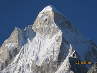
Mt Everest, South West Face, from Kalapatthar
We had reached Kalapatthar, the high point of our journey in more senses than one. Turning away from the flags, into the biting wind, there was a lot to absorb. Dot like, orange tents were visible to the left and below, marking the location of Everest Base Camp. Next to it, sweeping down in a giant arc of ice and snow, is the Khumbu Glacier, including the eponymous ice fall at its head. Directly above the ice fall is a squat pyramid of rock and ice, culminating in a peak known as the West Shoulder of Everest. To its right, the gangly pinnacle of Nuptse rises awkwardly, accusingly, piercing the bright blue sky. Following the line from Nuptse to its left we could spot a trough filled with snow. This is the South Col: the last and highest camp on the most popular route for climbing Everest, well and truly in the “death zone”, and the setting for numerous stories of heroism and hubris. To the left of the South Col rises a black pyramid, simply towering over everything else.
Mt Everest didn't present itself as a snow peak; its massive south-west face was mostly black, with streaks of white where snow had accumulated on its ledges. For a moment the concern about our inhospitable surroundings at 18,000 ft deserted us, as we tried imagining what the conditions must be like another 11,000 ft higher. We checked off milestones of the route pioneered by climbers of the 1950s, completed for the first time by Hillary and Tenzing in 1953: the Khumbu Icefall, the Western Cwm, the Lhotse face (hidden by Nuptse), the South Col, the south-east ridge of Everest, its South Summit, and finally the main summit at 8850m. This morning, like on other days on the trek, the top of the world was marked by a brilliant snow plume glistening in the morning sun - impossibly high, isolated, and out of bounds. Throughout the Everest Base Camp trek, Everest plays second fiddle to Lhotse, the 4th highest peak in the world, merely peeping out from behind the formidable barrier of the Lhotse-Nuptse ridge. Here though, in the cradle overlooked by the goddess, there is no doubt as to who holds center-stage.
Day 1: Lukla to Phakding (2610m/8613ft)

A Dornier lines up for taking off from Lukla. Down, Up, and Away.
A week earlier, Saumya, Saurabh, Ranjita and I had landed at Lukla in a 15 seater plane, at the much maligned airstrip set at a 12 degree incline, perched on the edge of a 2000 ft precipice. Edmund Hillary had led the construction of Lukla airport, and in his “View From the Summit”, he describes how a few hundred partying Sherpas helped flatten the land to create a base for the runway. The slope is useful, aiding in braking during landings, and acceleration during take offs. When the weather is clear and the winds are low, flights movements are frenzied, with either a departure or arrival taking place once every 5 minutes. However, as the morning progresses, the near constant drone of twin engines gives way to something more intermittent, and by the afternoon, when the clouds roll in, peace returns to the mountains.
Geoff had missed his connection in Newark, and was running a day behind schedule, so we had a whole day to kill. Unfortunately, Lukla is a one-lane, pit-stop of a town, bereft of character. Visitors are either eager to get on with the trek, or are simply dying to leave the mountains. The high points are a couple of nice coffee shops, including a copy-cat Starbucks. Luckily the lodge we stayed in had a nice courtyard in the back and a warm dining room. We ventured across the street for dinner, but oddly didn't feel very welcome. Perhaps the owner didn’t like serving us lowly trekkers – he appeared to be friends with David Breashears, the famous mountaineer, and cinematographer for the Everest IMAX movie.
Apart from that first evening, we got great food all through the trip. You can’t go wrong, whether you opt for DBT (Dal, Bhat, Tarkari), noodle soup, or the pizza/pasta/burger parts of the menu. But if you’re accustomed to traveling in the Indian Himalayas, beware, the prices will shock you.
Geoff arrived the next day. Ranjita and I had perched ourselves on a grassy patch in the morning watching the flight movements, and at soon enough, spotted Geoff get off his Dornier in his trademark yellow shirt. He didn’t seem very much affected by jet lag, and immediately after lunch we were ready to start, eager not to lose any more time.
The trail from Lukla to Phakding is along 6 km of upstream hiking along the Dudh Kosi Valley. But since you start at Lukla which is high above the river, hiking to Phakding, you lose about 250m of elevation. However the trail is true "Nepali Flat", taking you up and down terraced slopes while skirting or criss-crossing the fast and furious Dudh Kosi, and hence provides a moderate workout. The quality of bridges in the Khumbu region is excellent. Most river crossings are via sturdy metal suspension bridges, an indication of the huge volume of traffic that passes through these valleys. Trekker lodges dot the route at regular intervals. It’s interesting how in spite of the large supply of lodges there are still more under construction. It’s probably a case of “build, and they will come” rather than trying to meet existing demand. But it does makes you wonder about the longer term impact of the trekking industry. Even though we were at the on the trail during the busiest month of the year, we had no trouble finding a place to stay anywhere. We reached Phakding in a couple of hours, and eased ourselves into a lodge where hot showers and great food awaited us. The protected valley meant a more comfortable night than the previous one in Lukla.
Day 2: Phakding to Namche (3440m/11286ft)

Namche Bazaar, the capital of Solu Khumbu district
This is a key day of the trek which many find hard. After meandering along the valley for a while, the trail climbs steeply to Namche Bazaar, the largest town and economic hub of the Solu Khumbu region. The trail was crowded with trekkers and mule trains, including some that were carrying loads for expeditions. Even though October isn’t the climbing season for Everest, there’s no dearth of challenging peaks in this region, ranging from the so-called “Trekking Peaks” to technically demanding ones. Some of the expedition mules had giant yellow cylindrical bags strapped to their backs with prominent North Face logos on them.
The trail is wide, and well-worn by animal and human traffic. The initial part runs along the floor of the Dudh Kosi valley. About two hours later, we reached the entrance to “Sagarmatha National Park”, where we bought permits that had to be produced on a regular basis on higher parts of the trail. Just as the name Everest represents colonial appropriation of the world’s highest mountain, “Sagarmatha” is the Nepali government’s attempt at the same thing. It matters little that the Sherpas of Khumbu have worshipped the peak as Chomolungma (Mother Goddess) since times far before either the British or the Nepalis spotted its imperial and commercial value.
For most trekkers the hike up to Namche is a slow one, due to the tough gradient and increasing altitude. On the way up, we met a Tamilian couple, perhaps in their early 60s. They were on their way back after a successful trip, and were ecstatic about their experience. It was inspiring to see their enthusiasm for the mountains even though their appearance went against the grain of stereotypical trekkers. On the same section, we got chatting with a local guide, who was familiar with Bangalore, having spent time at Sai Baba’s ashram in Whitefield. About half way up, a small clearing appears on the right of the trail, from where you get your first views of Everest - a black triangle jutting out from behind a massive horizontal ridge connecting Lhotse and Nuptse. A resourceful fruit seller had set up shop there, pointing trekkers to the mountain, but asking for Rs 100 per orange.
We reached Namche around 2 pm, about 6 hours hours after leaving Phakding (including a long break at the park entrance). At Namche, we checked out a slightly dingy establishment but finally the decision was made when we were chased away by the owner once he detected hesitation on our part. In the end we settled on the Yak Hotel, run by the very resourceful Mr Chime Sherpa, which turned out to be just great. The rest of the day went in exploring the fascinating streets of Namche with its hundreds of little shops aimed squarely at the tourist and trekker, and drinking gallons of tea and hot orange. Hot orange is a popular drink in these parts, introduced to us by Geoff. It’s essentially Tang and hot water, which might seem like an odd combination, but Geoff swears by it, and very soon, in the cold mountain air, he had the rest of us hooked as well.
Day 3: Namche Bazaar and surroundings (13000ft)
I first read about Namche when I was seven, in a Bengali school book of short stories. The remoteness and danger captured in that text was nothing like the comfort of commerce that Namche now is. Namche sprawls, amphitheater-like, across the head of a valley, topped by a near horizontal ridge with the grand snow pyramid of Thamserku (6,608 m) overlooking it. It’s a wonderful town, with ample electricity entirely generated from local mini-hydel sources. It has ATMs, internet, schools, and a wide range of hotels. One can easily spend a few days in Namche, exploring the town and hiking up to its higher points. While Namche is great for the average trekker, its less commercial neighboring villages provide better examples of what Sherpa life is really like.

Lhotse (right) and the Lhotse-Nuptse ridge, with Everest peaking out from behind.
This was an acclimatization day, so we made sure we didn’t gain much altitude while at the same time, staying active. A short hike up from Namche brought us to a museum, from where we got clear views to the north, along the Imja Khola valley. We spent a good deal of time here studying the map to get our bearings as we absorbed the views of Ama Dablam, Lhotse and Everest. Later, we hiked up to the Everest View Hotel. This hotel is perched at 13,000 ft, making it a strenuous hike even if you move slowly. The hotel is a tasteful design in glass and wood, but incredibly expensive - at inauguration, they apparently piped oxygen into the rooms, and flew dignitaries in to a makeshift airstrip at nearby Syangboche. The views of the peaks and the northern parts of the trail are superb from here, and provide a preview of the next couple of days of hiking. The deck was completely full, mostly with westerners who were willing to pay exorbitant prices. We squeezed into a table, but when it looked like the service wasn’t going to match the prices we decided to get moving.
We took the long route back to Namche, stopping at the quiet village of Khumjung for lunch. Khumjung spreads itself out on gently sloping land at the base of a minor peak and is the perfect contrast to Namche. Our host was an Everest summiteer and we were his only lunch customers (except for a stray cat). Khumjung lays claim to the remains of a “Yeti Head” which is on display for a small fee at the local monastery. None of us were convinced, and sure enough, some reading revealed it to be a hoax. The “Yeti Head” is made out of deer hair. Feeling a little underwhelmed by the skull viewing experience, we hiked back down to Namche through Syangboche, on some rougher and steeper mountain trails. That evening was well-spent at the German Bakery opposite our hotel, admiring the views of Thamserku bathed in moonlight. I was feeling the altitude a bit, and was glad to get a good night’s sleep. Geoff got to sleep in the owner’s room, because that had the only free bed left in the hotel.
Day 4: Namche to Tyangboche (3867m/12687ft)
We left Namche a little regretfully around 8, and hiked up and out of the valley. Soon we stopped at a view point with a chorten where a bunch of Korean trekkers were taking photographs, with whom Saumya tried valiantly to have a meaningful conversation. The next hour or so was along fairly level trail, which stayed high above the Imja Khola valley to our right. Looking north, the village of Phortse came into view, perched on a plateau high above the confluence of the Imja Khola and Dudh Kosi. On the way back we would pass through it, but right now, the trail quickly dragged us all the way down to the valley floor. We stopped for a tea break to prepare us for the next leg, where the authentic “Nepali Flat” experience would make us gain back all the altitude we had lost since the morning.
After crossing the river we met two young men from Delhi who were attacking the steep, forested, uphill trail cursing their decision to make the trip. Their complete lack of mountain experience was obvious, and they were clearly struggling with rhythm. We would meet them again in Dingboche, where over a cup of coffee, we discovered one of them was an engineer from the same institute as Ranjita and me. They ended up doing just fine in the end, but at this point of the trek we shook our heads disapprovingly, like the old men in Asterix in Corsica, at their lack of wisdom in choosing this as their first Himalayan trek. It was reasonably tough going on this section – warm in the earlier parts, with the altitude starting to kick in later. It felt good when we finally walked through an ornate Buddhist gate decorated with fairly grotesque images (common in Himalayan Buddhist art) to enter Tyangboche.

Prayer session at the Tyangboche monastery
Tyangboche is a large meadow at nearly 13,000 ft, with a smattering of lodges and a major monastery whose dating back to 1923. It boasts great views of the Everest/Lhotse ridge and Ama Dablam. We reached Tyangboche around 1 pm, and settled into a ramshackle lodge that the owner of the much nicer Yak Hotel in Namche had recommended (he said something about his sister running it, but mentioning his name in the dining room didn’t fetch us any warmth). It was located in a small grove of trees behind the monastery, so it was slightly protected from the winds that blew across the meadow. The afternoon was cloudy and windy, so peak views were intermittent. We spent the rest of the day visiting the monastery and sitting through a prayer session along with hordes of other trekkers, celebrating Saumya’s birthday in the fanciest café in Tyangboche, and then huddling together in the dining room of the lodge, chatting with other trekkers. The night was cold, thanks to the creaky construction of the lodge – it was mostly wooden planks somehow held together by nails. The rooms were railway coach-style, lined in a row, with a single bathroom at the end.
Day 5: Tyangboche to Dingboche (4530m/14800ft)
We set out at about 8 am, hiked across the meadow, and quickly dropped back into the valley below, always heading north towards the increasingly imposing Lhotse wall. Somewhere around this time I started to feel a little feverish, and all of the sudden the chortens, the river below, the beautiful view of the trail stretching ahead of us with Lhotse at its head all seemed very tiresome. At one point on the trail we saw a door walking away from us at a steady pace. Getting closer, we found see it was a young boy carrying a door on his back.
Around noon I was more than glad to hike up and over a rocky outcropping dusted with snow, to see the sprawling village of Dingboche come into view. Feeling relieved that the next day would be a rest day, I pushed on. Saurabh and Geoff made some enquiries, and we settled on the Green Tara lodge, right next to Mama’s Bakery, which came recommended by Swapnesh, a friend from Bangalore who had done the route a few months prior. Soon after lunch I was fast asleep under the blankets. However this was after negotiating the owner’s son, a 5 year old who was intent on drenching every passerby with cold water.
Tree-less Dingboche spreads itself across a wide valley with magnificent views. Right across from the lodge, on the true left of the valley, a fresh profile of Ama Dablam presents itself, sweeping upwards in a grand display, something like Shivling from Tapovan, displaying twin peaks instead of one. Lhotse appears closer, and Everest is no longer visible. In the distance, to the right of Lhotse, the valley turns to the right, where at the turn you can spot Lhotse Shar and a bit of Island Peak.
A slightly comic incident happened at the lodge. Saurabh went to chat with the lady who was cutting vegetables for the evening meal. She asked him where we were heading, and Saurabh said, “Kalapatthar”. Innocently, he asked, “Have you been there?” She replied, a little wistfully “Kalapatthar… No”. Continuing to work on her vegetables, she added, “But Everest, two times”. That pretty much ended the conversation.
Day 6: Dingboche and day hikes

View north from Dingboche
There was a dusting of snow early next morning, and I felt well enough to step out in the pre-sunrise glow to get views of the Lhotse ridge. Ama Dablan looked gloomy and bitterly cold (the sun rises behind it). At breakfast, we assessed how everyone was feeling, given that we were now at about 15,000 ft. Saurabh and Saumya were doing well, and discussed plans of hiking up the Valley towards the village of Chukhung which serves as a base for climbing Island Peak, and also provides stunning views of the Lhotse Wall. A young solo trekker who had summited Island Peak was heading out in that direction, so the energetic duo wrapped up breakfast and soon the three of them were off. Geoff and Ranjita were doing well too, but decided to take it easy. I had recovered from the fever, but was happy to take a rest day.
After Saurabh and Saumya left, we continued a leisurely breakfast with endless cups of tea. The lodge served a greasy eggs and hash browns that was quite a hit with all of us. Apart from us, the dining room had an elderly Britisher who spent the whole day there, reading a book, coughing a lot, and clearly not doing very well. He seemed a little irritated at another slightly chatty person who had returned from Island Peak after an unsuccessful attempt and would tell anyone who was prepared to listen that Island Peak isn’t what the guide books and trekking agencies make it out to be – according to him it’s much harder and more technical than you’d expect. He turned around due to altitude, weather, and concerns about safety, and felt the others in his group were insane to continue. From what I head read, the Nepali Government doesn’t help by euphemistically categorizing Island Peak (as well as a few other non-trivial peaks, like Friendship Peak) as “Trekking Peaks”, creating the impression that you can walk up. The impression I got (after a few more similar conversations elsewhere on the route) was that to attempt any of these peaks, it’s well worth learning basic ice axe technique, and skills for glacier movement and cold weather survival. These skills aren’t hard to acquire, but commercial outfits in Nepal only provide a quick crash course en route, and you end up with hardly any time to master them, especially when you’re already struggling with acclimatization.
Late that morning we decided to stretch our legs a little, and hiked up the ridge behind the lodge. The views of the valley got more expansive the higher we went, and the complex of peaks to the north east became increasingly impressive. Island Peak swung into view – the black, rocky mass sticking out from ice and snow is what gives it its name. To its left is Shartse, and the huge peak of Lhotse, the world’s 4thhighest peak. To its right was a near perfect cone (we couldn’t figure out its name), and an impressive ice wall.
We stopped about half way up the ridge that would lead to a peak called Nagartsang (5616m). There were other hikers continuing up the trail to the summit, but we decided that our progress had already qualified as a good acclimatization hike. We hung around for a bit, admiring the stunning views all around, enjoying the crisp mountain air, the sunshine, the brilliant blue sky. Looking at the route Saurabh and Saumya had taken up the valley, we wondered how far they had reached. It was a perfect morning. Later that afternoon we moved over to Mama’s Bakery for some dessert, where we chatted with the two guys from Delhi who seemed to be doing much better compared to when we last met them on the slog up to Tyangboche. Saurabh and Saumya returned by evening – Saurabh was as energetic as ever – he’s a human dynamo. Saumya seemed a little out of sorts, and was happy to spend the evening by herself with a book.
Day 7: Dingboche to Lobuche (4940m/16200 ft)
It was bitterly cold the next morning. There were no clouds overnight, and the sunrise was just brilliant. The rest day had done me a world of good. There was a sense of anticipation now for the rest of the trek, since we were well and truly in ice, rock and snow country. We left Dingboche heading west, up and over the ridge we had hiked the previous day, leaving Dingboche and Ama Dablam behind us. The terrain was initially easy – a vast dry meadow with stunted shrubs, and a panorama of peaks in the distance. As the meadow began to give way to the more familiar rock and rubble, the beautiful snow peak of Pumori peeped out over the horizon and had gave us a teaser of things to come. From here the trail swung up and to the right, and then down across a glacial stream to a tea house at the base of a steep climb up to Dughla Pass. Geoff wanted to keep going, worried that Lobuche might be full: a valid concern, given the number of trekkers on the trail, and the paucity of lodges there. In the end he was out-voted, and we threw back a few shots of hot orange, before attacking the trail again. It was hard going for the next 30 minutes or so and we were unconcerned about the amazing views that were unfolding behind us.
One by one, we reached the top of the pass. Ranjita was the most visible, in her bright blue puffy. Everyone was mighty pleased, and with good reason. We were now at about 16,000 ft, doing well, and enjoying the brilliant weather, and scenery. Soon after the pass, the trail passes by many chortens and memorials built for climbers who have died on these mountains. On the way back we would spent a little more time here, but on the way up, the priority was to reach Lobuche. From the pass the trail flattens out and heads north along the true left of the the Khumbu Glacier, towards a wall of mountains - Pumori (7,161m / 23,494ft), Lingtren (6,697m / 22,100ft), Khumbtse (6,672m / 21,772ft). Lobuche however is on the true right, so at one point we had to cross the run off, which was wide and shallow, and get on to the trail that would lead us along the moraine for the rest of our journey. It felt like we were on the home stretch now, with the path ahead dominated by Pumori up ahead, and increasingly, Nuptse (7,861m / 25,791ft) to the right. Everest isn’t visible from here. In fact, it isn’t visible as long as you’re on the valley floor, not even at Base Camp, which is why many trekkers (like us) often choose to head to Kalapatthar instead of EBC. But its absence doesn’t take anything away from the grandeur of this section of the trek.

Khumbu Glacier at Lobuche
In a typical pattern, by afternoon the clouds rolled in, and by the time we reached Lobuche (around 2 pm), it was quite gloomy. The Khumbu Glacier flows right past the tiny settlement but to see it you need to hike for all of 5 minutes to the top of the moraine. From here you get to see the entire profile of Nuptse, rising 10,000 ft from the from the glacier. Nuptse isn’t really an independent peak though - it essentially marks the terminating point of the Lhotse Wall, hence in terms of topographic prominence, is dwarfed by Lhotse. But since you can’t see Lhotse from Lobuche, Nuptse remains mighty impressive.
Mother Earth Lodge at Lobuche, like most other places, had a charming dining room but Spartan sleeping arrangements. After dinner and several glasses of “Tatopani” later, we retired early, feeling the altitude. Ranjita additionally was feeling a little feverish. It was a tough to sleep that night, with the floors creaking every time someone walked by, compounded by the annoying sensation of pounding blood vessels.
Day 8: Lobuche to Kalapatthar (5645m/18519ft) to Lobuche

Red helicopters conducting evacuation operations
To avoid sleeping too high, we had decided to hike to Kalapatthar and back to Lobuche, skipping the more customary night halt at Gorak Shep (5164m/16942ft). Looking back, I would probably do the same, though if you’re reading this and planning to do the same, be prepared for a tough, long day at altitude on harsh terrain.
We started at 5:30 am, when it was still dark. The temperature was -15 C. A major blunder was not recognizing that when the outside temperature is this low the water in hydraition pack feeding tubes would freeze in minutes. It was our first experience hiking at such low temperatures. As a result, most of us hardly drank any water during the 2.5 hour trudge to Gorak Shep. I tried hard sucking on the tube to get the warmer water from the pack to melt the ice in the tube, but rarely got more than a few drops, enough to wet my mouth, but not more. It was bitterly cold, so I didn’t realize at the time that I was dehydrating right from the start.
The trail itself was harder than expected. There was a lot of lose rock and gravel since we were almost always on the glacial moraine. One or two times, the route was unclear, but there was little chance of getting lost, because the sun-drenched summits of Pumori, Lingtren and Khumbtse, Everest's western neighbors were right there to guide the way. But the constant ups and downs at this altitude were challenging, and it was easy to get irritated at minor things.
Saurabh and Saumya were moving slower than Geoff, Ranjita and I. On hindsight, we should have stuck together as a group to maintain a steadier pace, and keep each other in good spirits. Once we arrived at Gorak Shep, I downed a few glasses of hot orange before hiking backwards a little to see if I could spot them approach. They arrived as soon as we were getting a little fidgety, and were understandably in need of some rest and replenishment. At 9 am, we walked across a sandy flat from Gorak Shep, to start the hike up towards Kalapatthar. Again, we decided to move on ahead of Saurabh and Saumya, which at the time seemed to make sense, but looking back, was not the smartest move.

Slow and steady hiking up to Kalapatthar, with Pumori looming over
Kalapatthar (5645m/18519ft) is really a minor rocky outcrop on a lower flank of Pumori. At lower altitudes, it would be probably an hour long, easy hike up from Gorak Shep. Here, every step was an effort. Fortunately we got into a good rhythm, and took no breaks until we actually reached the prayer flags that mark the "summit". All the while, the scenery unfolded in all directions – Everest swung into view, still impossibly higher than where we were, bathed in the morning sun, sporting its customary plume. Being able to see the South Col was an incredible feeling. To our left, the 6,000m high Lho La pass, backed by the massive bulk of Chang Tse (7,543m / 24,747ft), looked far more formidable than we had earlier imagined based on a cursory reading of our topo map. We had then joked about a solitary Chinese soldier guarding the route in to Tibet. From here, it was clear that no human intervention was required to preserve Chinese territory from an unlikely Nepali invasion.
At Kalapatthar, it was still very cold, -5 C, even though it was 11 am, and the sun was strong. The wind was fierce, making it hard to stand in one place. We had to almost shout to hear each other over the whipping of the prayer flags. Geoff, Ranjita and I found a relatively sheltered spot among the rocks, and dug in to enjoy the place for at least a while before heading down. For the next 30 minutes or so we took photographs, and admired the miles and miles of high mountain scenery on all sides. We felt cradled by the high snow peaks all around us and humbled by the sense of history of the place. To our left was the natural fortress guarding the border, in front, the bulk of Everest and Nuptse, below us the Khumbu Icefall and Glacier dotted with tents at Everest and Pumori base camps, numerous glacial lakes, and to the right, fading into the distance an endless string of peaks, all the way to and past Ama Dablan – which distant and small compared to the giants nearby, had lost none of its beauty.

Everest, Nuptse and the Khumbu Icefall and Glacier, from Kalapatthar
The descent was quick and took about 30-45 min. I practiced a little trail running and found my Asolos to be up to the game. Incidentally, three of us were wearing the same shoes!
We met Saurabh and Saumya while descending, and told them we would wait for them at Gorak Shep and head back together. I didn’t have an appetite for lunch thanks to the altitude, and I remember just downing a couple of bowls of soup which on hindsight was a silly thing to do. Someone wise once suggested keeping a cheat-sheet of do’s and don’ts for use at altitude, since you can’t trust your judgment at the time.
Once we regrouped and were done with lunch, Geoff, Ranjita and I set out at around 3 pm for the long rocky trip back to Lobuche. Saurabh and Saumya felt up to hiking a little up the valley towards EBC. So we split again. The hike back was monotonous; the late afternoon gloom making it all the more tiresome. Ranjita was feeling quite poorly. Geoff wasn’t doing too well either, suffering mild flu-like symptoms. The lack of hydration and food was telling on me, and I was quite glad to get back to the comfort of Mother Earth when we did, around 5 pm.
Day 9: Lobuche to Pyangboche
A thin layer of snow blanketed the valley and glacier the next morning. It takes a while for Lobuche to get any sunlight, thanks to the mass of Nuptse blocking the eastern skies. We took our time getting ready for the walk out. Meanwhile we saw a helicopter land and execute an evacuation, likely to some victim of AMS. We had seen several such helicopters flying up and down the trail over the past couple of days.
We left around 9 am, after packing a good breakfast. Energized at the prospect of losing altitude, we made good progress along the glacier. This section was stunning, since we could enjoy the views without panting at every step. Our acclimatization levels were much better too, and the stress of how we would handle the hike up to Kalapatthar was now gone. The moraines were lightly snow-covered, and the glacial melt was a trickle, and the weather and views remained just fabulous. We were all smiling, taking pictures, and enjoying the gentle downhill gradient. In spite of lots of halts for photographs, it took just an hour to reach Dughla Pass, where we spent some time admiring the views, and a some silent moments at a Scott Fischer's memorial, a mountaineering guide who died in the infamous 1996 Everest disaster. From here the trail falls away steeply, so it’s goodbye to Pumori, Lingtren and Khumbtse. This is also where the trail to Cho La (part of the three passes route through Khumbu) branches off to the right. Saurabh definitely seemed ready to attack it, but after much pleading he relented.

Nuptse from the Khumbu Glacier
After a leisurely tea break at Dughla, instead of heading back to Dingboche to the east, we took the shorter, more direct route back through Pheriche. This was an exhilarating hour as well, as we descended into a wide valley cradled by Cholatse and Taboche, twin peaks each around 6500m high.
We passed grazing yaks, one bright blue glacial lake, and finally a grassy flat valley floor with small stunted shrubs, with numerous glacial streams criss-crossing it. After 3 days of rock and ice, this was a welcome change. Pheriche inched closer and closer, and around noon, we reached the Himalayan Lodge, which is reputed to be among the best in Khumbu. The lunch experience didn’t disappoint. We met a couple from New York City, one of whom had run the New York marathon the same year I did, so we had plenty to chat about. We also met another interesting character there – a Bengali gentleman, probably in his mid 50s. Within 5 minutes, with little prompting from our side, we learnt that he and his wife split their time between Delhi, San Francisco and the Khumbu region (there was a Kurseong connection too, but I forget the details), and that both of them are avid hikers. We never found out his real name, but "DSK Chatterjee" was deemed appropriate.

Lunch at the Himalaya Lodge, Pheriche
The post lunch hike was long. The term Nepali flat remained true to its sternest interpretation, and with clouds rolling in, it meant slightly cheerless hiking. Without much incident, we rolled into Pyangboche by 4 pm, at a comfortable 13000 ft. We stayed in a lodge a couple hundred feet above the roaring Imja Khola.
Day 10: Pangboche to Namche
Early next morning, Saurabh and I did a short speed-hike to explore a little bit of the trail to Ama Dablam Base Camp. We quickly descended to the river, crossed it on a bridge, and then climbed a steep slope up and out of the valley. Again, magnificent early morning views were on offer, including the brilliantly lit up Lhotse, Nuptse and the 26000 ft high ridge connecting the two, and the Kondge ridge to the south-east near Namche, bathed in a curious early morning pink. We climbed high enough to get clear views of the classic Ama Dablam profile, but it was still grey since the sun was well and truly behind it. Getting hungry for breakfast, and shivering in the cold, I decided I had had enough, though Saurabh looked all set to go on to conquer Ama Dablam!
We left Upper Pyangboche (which is where we were staying) around 9 am. Pyangboche sprawls quite a bit, so the next hour or so was through a fairly unbroken chain of developed mountain side, consisting of terraced fields of barley, potatoes, cabbage, and corn. All the while we had Ama Dablam, the queen of Khumbu, keeping us company. It got quite warm as we kept moving under the bright sun, and at one point we stripped down to just two layers. Looking across the Imja Khola, we could see the plateau of Tyangboche, where we had stayed on the way up. A red helicopter was depositing someone who looked quite important, probably a lama for puja at the monastery.

Ama Dablam is a constant companion for a major part of the trek
About 3 hours from the start, around noon, we trundled into Phortse, located on a triangular plateau, perched a thousand or so feet above the confluence of the Imja Khola and Dudh Kosi. Phortse is a beautiful Sherpa village, perfectly terraced, dotted with toy-like houses, with a monastery overlooking it from a high point. Our host at lunch was Karma Rite Sherpa, a 5 time Everest summiteer. In his opinion, Ama Dablam was technically the most challenging moutanining experience (which also includes 6 times summitting Cho Oyu, the world's 6th highest peak). Outside the climbing season he spends his time trail running (he won second place at the Everest Ultra in ‘07) and managing the lodge. It was quite humbling to have someone who could boast such capabilities and experiences cook lunch for us.
From Phortse, it was a steep, but rapid descent to the Dudh Kosi, which we crossed on a bridge, and then began a long, steep hike up through dense forest (initially), all the way to Monj, at the top of the ridge. I was feeling pretty good, and moved a little fast to catch up with Geoff and Ranjita who had started from Phortse ahead of the rest of us. They were sipping hot orange (our beverage of choice for the trip!) at Monj admiring the clear views all around. For once the afternoon was sunny, and just as well, since it was still a long way to Namche.
I goofed a little on the next section. It was such a lovely afternoon, I felt like running all the way to Namche. So we decided that I would move faster, reach Namche early, and ensure we all got rooms at the Yak Hotel. So I sped off, running the downhills a little uncomfortably, thanks to my Asolos and 30lb backpack, and but nevertheless enjoying the experience thoroughly, feeling really great. In the process, I must have missed the turn off for Namche, because at some point, I found myself quite alone on the trail, with the light starting to fade, and no sign of Namche. It was still a good trail, so I kept going knowing it must lead somewhere but I was beginning to feel a little nervous. In the end, it turned out I landed up in Khumjung, which was a relief because I now knew where I was, but disappointing, since I realized that I had probably added a few extra km to my route. I calmed down and decided to just walk the rest of the way through Khumjung and Syangboche in a replay of the day hike we did a week ago. I reached Yak Hotel at 4:30 pm, tired, but relieved. The others arrived about an hour later. Hot showers and Mr Chime Sherpa’s hospitality awaited all of us after a long day. Bliss!
Day 11: Namche to Lukla, and Leaving the Mountains

Goodbyes at the Yak Hotel, Namche Bazaar
We left Namche around 8 am, not before Mr Chime gave us a ceremonial send off with some scarves as souvenirs. I realize it sounds repetitive, but it was yet another beautiful morning. We descended rapidly into the Dudh Kosi valley, and stopped for tea at a really pretty tea house. Back at the National Park Entry point we signed out, indicating that everyone who went in actually made it back. The density of yaks was high on these sections, including several caravans carrying expedition gear. Lunch was at Namaste Lodge in Phakding at around 1 pm. It was warm under the afternoon sun and soon we were down to T-shirts for the first time, and Saurabh actually went into the river to have a bath. After lunch we jostled our way past trains of yak on the final push towards Lukla. As always the last stretch after 11 days of trekking seemed never ending, and every spur we turned would have us believe that it’s one more to Lukla. This went on for a while, and finally, we spotted the Lukla plateau and airstrip. It was almost 5 pm by the time we reached, a good 2.5 hours after leaving Phakding. With a nice sense of accomplishment and home coming, we walked through the town, past the local “Starbucks” and “Yak Donalds”, and deposited ourselves at our lodge.
Reaching Lukla was easier than getting out of it. Ranjita managed a seat on a plane the next morning – she got priority among us because she had a commitment in Bangalore she needed to get back to. The rest of us remained stuck in Lukla for a couple more days, thanks to strong winds, which would shut down the airport by 9 am. Saurabh spearheaded the effort to get us on one of the early morning planes and finally we left on Nov 2. Fortunately, we had slack in Kathmandu, so in spite of the Lukla hold up, we still had time to hike around the city, visit Bhaktapur, and enjoy the familiar comfort of the Sacred Valley Inn in Thamel.
Concluding notes:
Even though the EBC trail is well maintained, and there's an abundance of creature comforts along the way, this is NOT a recommended trek for beginners.
Be prepared for 3-4 days well above treeline, which can be mentally challenging, while you're also coping with the physical challeges of altitude and cold weather.
Keep a cushion of 2-3 days in your itinerary to allow for bad weather at Lukla
Plan for at least 2 acclimatization days on the way up.
It's a brilliant trek, no matter what people say about the commercial aspects.
Trail runners - this is a dream route. Well maintained trails, great local support in terms of food and lodges.
In the higher altitude parts, don't make the mistake of using hydration packs if it's cold, and stay together if you're in a group.

Comments
An excellent read. This is Subhrajit from www.adventureclicknblog.com and we would love to have your blogs listed in our website. We have also launched a credit system for contributions by which contributors can reimburse the points for cool travel stuffs (adventureclicknblog.com/moreblognearn.php). The credit points are a way of saying thank you for your sincere effort and time for writing.
Regards,
Subhrajit,
Subhrajit.ghadei@gmail.com
0091 8378997510
Education: B.Tech (IIT Bombay) & MBA (IIM Lucknow)