Stok Kangri Summit Attempt, Ladakh

View of the Stok Range from Khardung La overlooking Leh and the Indus. Stok Kangri is the highest peak near the right.
Trivia:
- Stok Kangri is a peak of the Stok Range, a spur of the Zanskar Range
- At 20,135 ft, it is the highest peak of the Stok Range
- In Jul/Aug, the climb can be accomplished with 2-3 camps, and does not need technical climbing skills, though ice-axe / crampons maybe required
- Trailhead is at 12,000 ft, at Stok Village, a short 30 minute drive from Leh
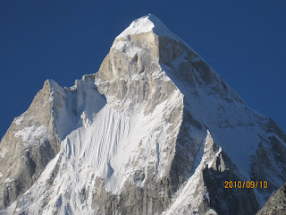
- Summit views include the Karakoram, and if you're lucky, you can spot K2
In July 2009, Ranjita, Geoff, Prasad and I attempted Stok Kangri (photos). We were optimistic about our chances, thanks to the excellent weather we had experienced in Ladakh throughout the previous week, and the ample opportunities we had had to acclimatize (side trips to Domkhar, Pangong Lake, Lamayuru, and just bumming around Leh).
The trailhead for climbing SK is at Stok Village, a green patch across the Indus (visible on the far left corner of the panoramic photo above). While the mules were being loaded, we got started. The hike takes you straight up the drainage of the Stok Chu (river). Even though there is no marked trail, one is hardly likely to get lost. You just keep moving upstream. The weather had been cloudy and drizzly since the previous evening, but it wasn't bad enough to dampen the initial exuberance of walking into a rocky wilderness attempting one's first Himalayan summit (well, if you're fussy, this is technically the Trans-Himalaya). After about 2 hours of steady progress without a break, we took a breather at a tea stall. We were clearly making good time, because it wasn't until another 15 minutes or so that Tukpa, our guide caught up with us. Tukpa is a young man with serious mountaineering capabilities and ambitions. He has climbed Saser Kangri (part of the Eastern Karakoram, it is the highest peak in Ladakh at 25,151ft) and hopes to do Everest in 2010. He directed us to bear left and climb a short but steep section up to a small pass, leaving to the right, the main route which crosses Stok La and enters Markha Valley (one of the most popular trekking routes in Ladakh). A few huffs and puffs later, we were at the pass, and took a minute to consider if we should wait for Tukpa (who in turn was waiting for the mules), or continue.

View from the mini pass, where the Stok Kangri route turns away from the 'main' trail that goes on to Stok La and Markha Valley
The view from the pass was beautiful in a harsh and violent way. A narrow rock and boulder strewn valley lay beneath us, sheer walls on each side, with glacier melt dodging over and under the valley floor which looked like rubble from an urban bombing raid. Prasad hot-footed his way down to confirm with some returning trekkers if upstream was the way to go (there was little doubt in any of our minds, including his, but one can never be too certain). Once we descended from the pass, it was a long, arduous, but spectacular hike through the canyon towards the first camp at Mankarmo at about 14,000 ft.
At Mankarmo we met someone who runs the local tea tent; he spends 2-3 months there, having supplies like Maggi, snacks and drinks ferried up to him by mule. Rs 50 for a bottle of Thums Up in a location like this didn't seem like a bad deal at all. The later afternoon at Mankarmo was magical, with Stok Kangri showing itself through the clouds, and the evening sun breaking through teh clouds to set on fire the ridges directly above the campsite. A herd of Himalayan blue sheep kept us entertained with their incredible sure-footedness as they scampered up and down an 80 degree incline for what seemed like just the heck of it.

Stok Kangri through a cloudy sunset from camp 1
On Day 2 we were greeted by blue skies. So we were on our way quickly, up an incline that got steeper and steeper (at least it felt like than thanks to the thinning air) as we moved towards Base Camp (~17,000 ft). Marmots to the right of the route provided numerous good excuses to stop and catch one's breath. However, the weather turned gloomy soon after. By the time we arrived at Base Camp, breathing heavily from the lack of oxygen (but no serious headaches), it was not looking good at all. We all collapsed into the tea tent, had lunch and considered our next move.

Under brilliant sunshine, we set out for Base Camp
Base Camp was nothing like the disaster zone that other trip reports had painted it to be. There were two toilets, and the camping area was quite clean by Himalyan standards. There was a handful of other groups, most of whom were waiting for good weather to make an assault on the summit. Our plans of a midnight start began to look extremely poorly as the sleet came down, and we ended up taking naps and reading. Later, all four of us huddled in one tent to play a few rounds of 29, our designated card game for Himalayan treks.
After a sleepless night interrupted by bad dreams and breathing trouble, we woke to a depressing sight. Tukpa had not woken us at midnight for the planned weather check - he probably took a look and deemed it pointless. In the morning snow had blanketed camp, and it was still coming down in flurries. Around 10 am, we tried on some snow gear, and I complained bitterly about the ill-fitting snow boots that Tukpa had brought along for me. I wasn't feeling all that great (headache, lethargy, lack of sleep), though none of the others seemed to have any issues. Tukpa gave us a short training session on self-arrest techniques using an ice axe, but at this point the exercise had taken on a distinctly academic feel. The only optimistic comment I heard was from the person in charge of our mules, who opined that the weather would clear up soon. However the man who's opinion mattered, Tukpa, did not share his enthusiasm.

A depressing start to day 3. In the original plan, we would have been half way to the summit by now
To give ourselves something to feel good about, we hiked up to the next ridge on the summit route, gaining another 500 ft or so from base camp. I instantly started feeling better as we fell into a slow but steady pace of ascent. However as we reached the ridge it was clear that conditions were depressingly soupy, and heavy, freshly fallen snow lay on the route in front of us, extending as far as we could see (which wasn't much, thanks to poor visiblity). We met a pair of porters returning from their overnight stay at Advanced Base Camp. Their party was abandoning its summit attempt and returning due to the heavy snow accumulated on the higher reaches of the mountain. Feeling somewhat vindicated we scampered back to Base Camp, where most of the other groups also appeared to be cancelling their summit plans. Very quickly, we decided to call it quits, and I for one felt a little relieved, not looking forward to the idea of negotiating a glacier with crevasses in less than ideal weather, in horrendously ill-fitting boots. I quickly made up my mind not to rely on untested, rented gear in the future (which also meant my next trip to REI would be an expensive one).

Hiking up to the ridge above base camp

Porters descending from ABC in near whiteout conditions

Savoring a few moments at the highest point reached before the long march back
The return journey was quick. The dismay increased as the sun came out just when we were about half way down, and by the time we reached Stok Village, it was blazing up above. The next day, as we looked at Stok Kangri from Khardung La, about 30 miles away, it was a picture perfect snow peak against a brilliant blue sky. We told ourselves that in spite of the good weather, the snow depth would have reduced our summit chances significantly. But secretly, everyone was disappointed that we weren't up there giving it a shot. Thanks to cellphone coverage which became available at some point during the hike out, Tukpa was snappily assigned a new client. We were met and then accompanied to the trailhead by the very business-like agent who set us up with Tukpa earlier. His commercial approach (further borne out by his behavior when it came to settling accounts) annoyed us quite a bit, and was in contrast with the humility and decency that one usually encounters in the Himalaya. This left us with bit of a bad taste in the mouth that only compounded our disappointment of failing to summit.

Mockingly, the sun comes out as we approach the trailhead at Stok Village
Summary:
Unfortunately we did not succeed in scaling Stok Kangri in 2009. A combination of bad weather and questionable judgment made us return to Leh after spending a cold, snowy night at base camp. On the brighter side, we each set ourselves a personal altitude record, ignoring potentially higher altitudes reached via road. We estimate the ridge above base camp to be around 17,500 ft. On hindsight, spending another day at base camp may have been the sensible thing to do; but the consensus to engage reverse gear was reached surprisingly easily. It was probably a combination of the effects of altitude, my dissatisfaction with my snow gear, and the low morale that seemed to have infected most other trekking groups that night at base camp. Disappointment is part of every serious trekker and mountaineer's experience. This was our first taste of it.
The rest of the fortnight in Ladakh was incredible nonetheless. Photos are split across two albums (i) Sightseeing and road-trips in Ladakh, including an amazing visit to a local NGO, HEALTH-INC and (ii) the Stok Kangri Trek and Nubra Valley.
Prasad created a wonderful, informative photo blog of the trip.

Comments
Here's how I dealt with our inability to complete the climb:
Apparently, according to Harish Kapadia, Stok Kangri is the most climbed 6000m peak in the world. In hindsight, maybe there was a reason why we didn't succeed.. :)
When I was there in 2006, the glacier only had two-three crevasses and you could make a nice jump across it.
Good to see that the tent before the pass to Mankarmo still sells Maggi!
Btw, my Mt. Kailash plans are becoming clearer: Check out: http://pallavgupta.homeunix.org/
The costs will be high so I'm looking for 2-3 people to join in.
BTW - I've started putting together a tentative plan for Kalindikhal:
http://trailmixandsnow.pbworks.com/Kalindikhal
It's early days, so let's see how it turns out.