Machu Picchu Via Salkantay Pass
(Photo credits: Scott Orth)

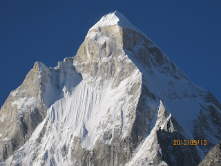
Initial views of Salcantay and terraced slopes from our breakfast location en route to Mollepata
The trek over the Salkantay Pass to Machu Picchu is rapidly gaining popularity owing to restrictions on the classic "Inca Trail". In 2008, The National Geographic listed this route among the "25 best adventure trips in the world", and the "savvy traveller's route to Machu Picchu". Of course, Ranjita, Snigdha and I had no idea about all this, and came upon this offering from SAS travels in Cusco after we heard there was no way of getting permits to do the classic Inca Trail. We found company in Megan and Scott, a Canadian couple with clearly plenty of trekking experience behind them, Rachel, an undergrad from Brown University who was at the time, on an exchange program in La Paz, Bolivia, Stephanie and Erica, two high-energy Dutch teenagers who were each about 2 feet taller than us, and Ulrich, a funny Danish guy who was living in Argentina because "the winters are too depressing in Denmark". We "chicos" were in the able hands of Juan from SAS.
Trekking Dates: May 23-27, 2005.
Andean Trivia
The trek takes you through gorgeous parts of the Cordillera Vilcabamba, a section of the Peruvian Andes. The highlight (other than Machu Picchu of course) is the Salcantay Pass, estimates for which range between 15,000 and 15,500 ft. Salcantay, which dominates most views on the trek, is the highest peak in the Cordillera Vilcabamba, at 20,500 ft, but it's only the 12th highest in Peru, and the 38th highest in the Andes. Huamantay (19,500 ft) is also very close to the hiking trail. From the pass, the Cordillera Blanca is visible, a group that includes Peru's highest peak Huascaran (22,300 ft).
Detailed Trek Report
Day 1: Cusco (10,800 ft) - Mollepata (9,300 ft) - Soraypampa (12,210 ft)
We assembled at 7 am at the Plaza at the center of Cusco, where we boarded a bus and met our trekking companions for the second time (We had a pre-trek orientation the previous evening). About 2 hours out of Cusco, we stopped on the roadside for a indulgent breakfast with inspiring views of the snow-capped Salcantay and Huamantay peaks. Another hour or so later we arrived at a village called Mollepata, where Juan arranged for mules, and where we, within 15 minutes, managed to lose the only sunscreen we were carrying. A short while later, we were off the bus, on a meadow, and ready to go.
The hike was pretty easy, through flowering shrubs, and views of terraced slopes, and occasional sneak peaks at Salcantay. The first campsite at Soraypampa arrived mid-late afternoon soon after a wide stream crossing, nestled in a moraine valley at the base of Salcantay. We experienced magical moonlit views of the snow peak and banal conversation with the rest of the gang in the dinner tent (yes, this was one of "those" treks), with of course, magnificent food to go with it (trout, potatoes, salad).
 Soraypampa, the first campsite, was located in a meadow with grand views of Salcantay
 Meals were an elaborate affair all through the trek. Dinner at Soray-"pamper"
The second day started with severely cold weather, with the sun taking its time to rise above the ridges. We passed a great example of a fan-shaped glacial moraine, which Scott pointed out to us. From there it was a long, steep climb executed with altitude-induced stupor, up and out of the treeline into boulder and rock country. At the Salcantay pass, we were greeted by brilliant weather, fantastic views of the Cordillera Blanca, a range containing Peru's highest peaks, and of course, since we were in the saddle connecting Salcantay and Huamantay, detailed close ups of these majestic mountains. We heard sharp cracks of ice breaking on glaciers, (or avalanches, we weren't sure which). From the pass, it was a longish but easy descent to the lunch spot, which we gobbled down after a gruelling 9 hour hike. After lunch, we set out on a dramatic descent into dense cloud forest. The trek was very similar to Captain Haddock and Tintin's trek to the Temple of the Sun, complete with llamas, snow peaks, waterfalls and then jungle and mosquitos (no Tapirs though). Also, our viewings of an Andean Condor high above us did not compare with Snowy and Tintin's encounters. We ended the day at a lovely spot called Chaullay, perched on a protected part of a hillside looking into a valley. Best of all, one could buy beer!

View from Salkantay Pass towards the Cordillera Bianca, and down into the cloud forest
Day 3: Chaullay (10,400 ft) to La Playa (7,500 ft)
Day 3: Chaullay (10,400 ft) to La Playa (7,500 ft)
The next day, after a hanging bridge crossing, we hiked along the Urubamba Valley, at times at water level, and at other times, hundreds of feet above it, watching it snake northwards through the valley (the Urubamba is a headwater of the Amazon). Occasionally, lookling back through the clouds that seem to live in this forest, we would catch of glimpse of Salcantay, now thousands of feet higher, and appearing different from the new perspective. We had the typical gourmet lunch, and got treated to freshly plucked grenadines. After a rewarding but relatively easy day's hiking, we arrived at the village of La Playa, where we camped next to a school building. We met many adorable kids that afternoon, and some of us played soccer with them, while others lazed around drinking beer (sold to us by a 7 year old), and followed Megan's lead stretching our hamstrings, much to the amusement of the onlookers.
 Rachel and Megan high above the Urubamba, snaking north towards Machu Picchu
Day 4: La Playa (7,500 ft) - HydroElectric - Aguas Caliente (6,700 ft)
We bade farewell to Juan's support staff as they would head to a nearby road and take a truck back to civilization, while we would continue hiking to Hydro-Electric (yes, that's what the place is called). They turned out incredible food at every meal, ensuring that no one lost a pound on the trek (sadly for some). We continued hiking with great views of the Urubamba, and then a tedious descent, during which Rachel and Ranjita sang morale boosting songs all the way down to the river (not the Urubamba, something else). Part of what made this section hard was neck-high grass, which obscured the views. At the bottom we crossed a very scary hanging bridge, where for a moment it looked like Snigdha was going to plop right through a missing plank. The falls near the Hydel station were spectacular, and it was a flat walk to the train station. We had lunch there, and then boarded a train that switchbacked it's way up the mountain, changing direction each time, until it reached the touristy, but nevertheless charming town of Aguas Caliente (which literally means, "hot water").
We explored the town a little, doing the naturally touristy thing of taking a bath in the hot springs, and roaming up and down the market street looking at trinkets. The hotel was little more than a trekker's hut with a dining hall.
Day 5: Aguas Calienta (6,700 ft) - Machu Picchu (7,900 ft) - Cusco (10,800 ft)
Early in the morning we hiked up to Machu Picchu in the dark, and were there well in time to see the sun rise over that magical place. As a bonus (or so we believed) we witnessed a llama threesome at close quarters. Later we would wonder if they're trained to entertain the tourists in this manner while they wait for the sun to rise. We spent the next few hours taking a guided tour of the ruins, but most of the group was so done with trekking that we passed on an opportunity to climb higher, up Huayna-Picchu, from where, apparently the views are spectacular. Lots of pictures later, we dragged ourselves away from the ruins and lay ourselves down on the grass to soak in the sun, and the reality of where we were.
 Sunrise over Machu Picchu: well worth all the effort
 Pleased as punch
 Inca statue, near the Aguas Caliente train station
Post Trek Thoughts
5 days for this trek (4 real trekking days) is a good pace. Weather was terrific end of May. One thing to watch out for is AMS. Since we were bumming around Cusco and the Sacred Valley (10,000 to 12,000 ft) for two days prior to starting the trek, we were reasonably acclimatized. Or maybe it was just the gallons of Coca Tea that we consumed!
5 days for this trek (4 real trekking days) is a good pace. Weather was terrific end of May. One thing to watch out for is AMS. Since we were bumming around Cusco and the Sacred Valley (10,000 to 12,000 ft) for two days prior to starting the trek, we were reasonably acclimatized. Or maybe it was just the gallons of Coca Tea that we consumed!
Traveling with SAS was a good experience, if somewhat expensive ($350 per person, for the 5 day trip), since they cater principally to US/European travellers. There are probably many agencies around Cusco that offer equally good services for much less. Well, maybe the food won't be as spectacular as SAS, but then, you don't go trekking for cuisine.

Comments