Kuari Pass, Garwhal Himalaya
Introduction
The trek over Kuari Pass in Garwhal District of Uttarakhand State in Northern India. The trail climbs from Ghat, a small village near Nandprayag, heads directly north over several passes, the most spectacular of which is Kuari, before descending to Auli, the popular ski resort near Joshimath. It's about 70 km long, and can be done at a leisurely pace in 7 days. The highest point reached is Kuari Pass, for which elevation estimates seem to hover around 14,000 ft. Oct and Nov are recommended for clear skies.
Major Himalayan Peaks Viewed
Getting there
Our group included Geoff Voelker, Srivatsan Laxman, Prasad Naldurg, Ranjita and I, all from Bangalore. Reaching Nandprayag (the trek base) was a considerable challenge, involving enormous delays at Bangalore Airport (the old one), a missed train connection in New Delhi, a scary ride through the dead of night on what passed for a highway connecting Delhi and Hardwar (at one point our driver bashed his head into his own door), a 4 am rendezvous with another taxi who was waiting for us at Hardwar station (the actual meeting and transfer of luggage took place at a horse urinal), and finally, a 9 hour bone-jarring drive through the magnificent Alaknanda Valley. We finally reached Nandprayag exhausted, but with enough energy to make contact with Gyan, our friend, philosopher and guide for the next week. I hit the sack in the crummy GMVN rest house while others figured out next steps.


The return was thankfully less eventful than the outward journey. After we tore ourselves away from the views of Nanda Devi, our ride took us back to Karnprayag, where Srivatsan and Prasad went on to Naini Tal. Ranjita, Geoff and I went down to Rudraprayag, and spent the night in what we (then) considered to be the worst hotel we had ever stayed in. The next day, we reached Hardwar early enough to spend a few hours walking around the town, and a quick hike upto the crazy temple on the West Bank of the river (highly unrecommended). The evening Shatabdi to Delhi was smooth as silk and the layover in Noida was pretty convenient thanks to my colleague Anup's contacts in the area. Next day, mid-morning, we were back in Bangalore, battling traffic and pollution, but at the same time, bathing in the afterglow.


The trek over Kuari Pass in Garwhal District of Uttarakhand State in Northern India. The trail climbs from Ghat, a small village near Nandprayag, heads directly north over several passes, the most spectacular of which is Kuari, before descending to Auli, the popular ski resort near Joshimath. It's about 70 km long, and can be done at a leisurely pace in 7 days. The highest point reached is Kuari Pass, for which elevation estimates seem to hover around 14,000 ft. Oct and Nov are recommended for clear skies.
Trekking Dates: Nov 18 - 24, 2007
Major Himalayan Peaks Viewed
- Nanda Devi (25,643 ft)
- Kamet (25,446 ft)
- Abi Gamin (24,130 ft)
- Mana Parbat (23,858 ft)
- Mukut Parbat (23,760 ft)
- Chaukhamba (23,419 ft)
- Dunagiri (23,182 ft)
- Ghori Parbat (22,136 ft)
- Haathi Parabat (22,070 ft)
- Changabang (22,520 ft) [We continue to hope]
- Neelkanth (21,640 ft)
- Nanda Ghunti (20,819 ft)
- Ronti (19,819 ft)
- Pangarchula (17,602 ft)
- Brahmakamal
Trek Itinerary (approximate elevations and distances)
- Day 1: Chefna (3000 ft) - Ghuni, 8 km, moderate
- Day 2: Ghuni (4500 ft) - Chechni Binayak (11,000 ft) - Jhinji, 11 km, strenuous
- Day 3: Jhinji (6000 ft) - Pana, 8 km, moderate
- Day 4: Pana (8000 ft) - Unnamed Pass - Sartoli, 8 km, moderate
- Day 5: Sartoli (10,000 ft) - Dakhwani, 8 km, moderate
- Day 6: Dakhwani (13,000 ft) - Kuari Pass - Talli, 12 km, moderate
- Day 7: Talli (12,000 ft)- Auli (10,000 ft), 8 km, easy
Our group included Geoff Voelker, Srivatsan Laxman, Prasad Naldurg, Ranjita and I, all from Bangalore. Reaching Nandprayag (the trek base) was a considerable challenge, involving enormous delays at Bangalore Airport (the old one), a missed train connection in New Delhi, a scary ride through the dead of night on what passed for a highway connecting Delhi and Hardwar (at one point our driver bashed his head into his own door), a 4 am rendezvous with another taxi who was waiting for us at Hardwar station (the actual meeting and transfer of luggage took place at a horse urinal), and finally, a 9 hour bone-jarring drive through the magnificent Alaknanda Valley. We finally reached Nandprayag exhausted, but with enough energy to make contact with Gyan, our friend, philosopher and guide for the next week. I hit the sack in the crummy GMVN rest house while others figured out next steps.
Devprayag: The Bhagirathi and the Alakananda merge to form the Ganga
Nov 18: Nandprayag (3000,ft) - Chefna (Jeep) - Ghuni (6600 ft)
Bouncy Jeep ride to Ghat, where we had breakfast in a typically filthy bazaar area, but the chai shop had terrific views of Nandakini. The jeep took us further upstream, to Chefna, where we started the trek. The first few hours passed climbing out of the Nandakini Valley, through villages, with a bunch of kids keeping us company. It was a warm start to the trek, ending at a meadow just above a village called Ghuni, located a km or so from the older route's first camp, Ramni. At a modest 6600 ft, Ghuni boasts terrific views of the Roopkund route and Ali Bugiyal. The night turned very cold, with frost covering the tents in the morning. People encounters: an 81 year old cow herd named Thakur Khettry, who was quite the caste proud one, and 5 year old Surinder, who was quite the precocious one.

Surinder - a kid we made friends with on the trail, backed by the Chaukhamba Massif
Nov 19: Ghuni (6600 ft) - Chechni Binayak (11,000 ft) - Jhinji (6000 ft)
A good grinding awaited us on Day 2, after slurping down a breakfast of Dahlia. The trail (whatever there is of it) climbs about 3000 ft to Chechni Binakay, a pass at approximately 11,000 ft. Beautiful views of Nanda Ghunti along the way, through the pine forests and at the occasional clearing. The massive Chaukhamba also makes a fleeting appearance. The rest of the day was a steep descent through cold, dense jungle where the green was balanced by changing colors of autumn. With trembling knees and low morale, folks arrived at Jhinji, our next village/campsite. The location had everything going for itself in terms of setting --- hemmed in by sheer slopes rising thousands of feet off the valley floor, crowned by snow peaks. However, the local scenery was another story --- the campsite had comparable amounts of dung, trash, and grass. We feasted on a simple lunch of khichhdi and an incredible dinner of roti, local radish, moong daal and baingan bharta, and even managed to make a couple of phone calls at the local "STD booth".
Nov 20: Jhinji (6000 ft) - Pana (8000 ft)
It was considerably warmer than Ghuni down in this valley. After watching the sunrise on the snowpeaks, and consuming a breakfast of cornflakes, boiled eggs, and bread, we made a start around 9. The sharp descent continued into the Birahi Ganga Valley. Met a bunch of adorable kids named Manju, Kamala and Vikas on the way.
We crossed the river on an impressive footbridge, several hundred feet above the roaring waters, then switchbacked out of the valley, initially keeping Jhinji in view. Then everything changed. A swing to the right, and we were looking straight down the Birahi Ganga gorge, including the remnants of a now non-existent Gohna Tal (google that incredible story that washed away the downstream town of Srinagar). Another 7-8 km of pleasant, moderately flat hiking through fall foliage, and we were at Pana, a pleasant campsite at the base of one of the peaks visible from Jhinji, part of the Pagarchula Ridge. We washed up in the freezing mountain stream, Geoff lost his soap to some mountain crows, and we whiled away the time playing Two Truths, One Lie, situations, and by having endless arguments about the orientation of the Big Dipper. We had hot chocolate after dinner!
Hanging bridge over the Birahi Ganga, below Jhinji
Looking west down the Birahi Ganga Valley and Gohna Tal
Nov 21: Pana (8000 ft) - Unnamed Pass (11,000 ft) - Sartoli (10,000 ft)
10 hours of sleep later. Cold morning, slow going. We hiked up and out of the Birahi Ganga Valley till we were level with the Chechni Binayak pass on the other side of the river. It's a steep, but rewarding climb, with stunning views of Nanda Ghunti flanked by Ronti on the left, and an unnamed peak on the right. With binoculars, we could make out many feature details: huge snowfields, knife-like, corniced snow ridges. At this point, the trail turned away from the valley, crossed a pass, and swooped down a new valley towards Sartoli, a classic grazing meadow, with the climb to Kuari Pass towering over the landscape. The ridge from Kuari, extended to the right, peaks at Pagarchula, visible two days ago from Jhinji. We dropped a little lower than Sartoli to camp after 4 hours of moderate trekking. Ranjita entertained us with card games, and I nearly (keyword "nearly") had my roll of toilet paper roll into an abyss while I was in a somewhat helpless position. The evening was freezing cold, so the campfire was a warm welcome. However, the night continued to remain extremely cold.
Nov 22: Sartoli (10,000 ft) - Dakhwani (13,000 ft)
Aloo paratha for breakfast! We descended sharply to a spectacular waterfall. Bridge-crossing, and valley hike out. That's the story of the Kuari Pass trail: Work hard to gain a few thousand ft. Take in the views. Lose it all in the next 2 hours. Repeat this for a week.
The trail climbs gradually there on to Dakwani, an exposed area a little way up the steep slope leading to the Pass. It was a short day - 3 hours no more. At this point, some of us had plans to going up teh ridge higher than the pass the next day. Would be cool maybe even to make a summit attempt on Pangarchula.
The campsite was great - clean, maybe ~1000 ft below the pass. Gyan is a terrific guide - very knowledgable, and a good person. We spend a sleepy afternoon listening to mule bells, the gurgling stream, and playing cards. Interestingly the night was not as cold as the previous, but far more windy. We hit the bags by 8 pm, looking forward to an early morning strike at the Pass and a possible Pangarchula attempt.
Nov 23: Dakhwani (13,000 ft) - Kuari Pass - Talli (12,000 ft)
The best day of the trek. Puri / chhole for breakfast, and an early start. We received brief respite from the gruelling ascent to the pass thanks to sightings of a Monal: lovely Himalayan high altitude bird. Expansive views of the valley behind us, including the Sartoli area. Very steep gradient, freezing cold, altitude make it worse. Take 10 steps, stop and breathe. We reached the pass around 9:30 am and .... what can one say. Brilliant sunshine, not a wisp of cloud, and a few hundred miles of the High Himalaya on display. Chaukhamba in the west, followed by Nilkanth, then the Alaknanda Valley piercing a route north towards Tibet, then a group that likely included Mana, Mukut and Kamet, Abu Gamin. Nilgiri, Ghori and Hathi Parbat were smack in the middle of the view, and to the right, the magnificent Dunagiri, and maybe, just *maybe*, Changabang. Also visible were the Rishi Ganga and Dhauli Ganga Valleys.

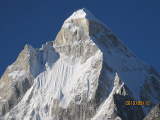
Snow views en route from Kuari Pass to Talli

Dramatic scenery near Kuari Pass
After spending 90 min at the pass, mesmerized by the view and the pleasant weather, we abandoned all plans of climbing higher. We spent the next 2 hours on a dramatic hike, as Gyan led us through ridges, meadows, and snowfall that gave us newer and closer perspectives on the pantheon we observed from the pass. Nanda Ghunti and Ronti also swung back into view after a day's absence over and above the Pagarchula Ridge. Soon we sank into a pine forest and reached a sublime campsite at Talli surrounded by pines, and blanketed with snow. Many excited discussions over the campfire about the day's views, including suggestions that we might have already sighted Nanda Devi.
Nov 24: Talli (12,000 ft)- Auli (10,000 ft)
Coldest night of the trek. We settled accounts on a cold morning, and started by 8 am. The hike gradually became more exhilarating with sharp fall offs to the right, and views directly upstream along the Rishi Ganga Valley, which means, yes, Nanda Devi, the highest peak entirely contained within India, was in view, and changing colors by the minute. The dramatic appearances of Dunagiri continued, and so did the raging debate on the identity of the peaks just east of the Alaknanda, with the idea of having seen the Kamet group of peaks gaining acceptance. We received views of the confluence of Rishi Ganga and Alakananda (at Vishnuprayag) as well as the Rishi and Dhauli Gangas. We sighted Lammergier, a Bearded Vulture overhead, by which time Auli was within view below us. The trail runs through brilliant meadows, sneaking in and out of pine forests, before arriving at Auli ... at a chai shop! By the time we arrived, Nanda Devi was alive with sunlight and sublimation, so no one really complained when our jeep was late showing up. We played with a couple of local dogs to kill the time until the jeep arrived, one of which must have been the world's dirtiest puppy.


The dirtiest puppy in the world backed by Neelkanth
Over and Out
The return was thankfully less eventful than the outward journey. After we tore ourselves away from the views of Nanda Devi, our ride took us back to Karnprayag, where Srivatsan and Prasad went on to Naini Tal. Ranjita, Geoff and I went down to Rudraprayag, and spent the night in what we (then) considered to be the worst hotel we had ever stayed in. The next day, we reached Hardwar early enough to spend a few hours walking around the town, and a quick hike upto the crazy temple on the West Bank of the river (highly unrecommended). The evening Shatabdi to Delhi was smooth as silk and the layover in Noida was pretty convenient thanks to my colleague Anup's contacts in the area. Next day, mid-morning, we were back in Bangalore, battling traffic and pollution, but at the same time, bathing in the afterglow.
A happy meal at Pipalkotti. Clockwise: Ranjita, Prasad, Geoff, Srivatsan
View of Hardwar, from the crazy Manasi Devi temple
Random Thoughts
7 days is way too padded an itinerary. 5 days should be do-able. I would break it down as follows:
Day 1: Chefna - Ghuni
Day 2: Ghuni - Jhinji
Day 3: Jhinji - Dakwani
Day 4: Dakwani - Talli
Day 5: Talli - Auli
It might be well worth throwing in a summit attempt, or ridge walk up and to the right of the pass. What else. Gyan is a great guide. He pampers you a tad more than you might like, but he's a good listener, and very knowledgeable. Highly recommended.

Comments
Kalanka (22,740 ft)
Bethartoli (20,840 ft)
Kedarnath (22,770 ft)
Arwa Tower(?) (20,840 ft)
But like Ranjita said, it may take a whole lifetime to list them all..
thanks ..
ravi boparai