Langtang Valley
Until 2015, Langtang Valley was Nepal’s third most
popular trekking region (after Khumbu and Annapurna). The Nepal Earthquake of
2015 changed that, specifically by destroying the village of Langtang, the
economic center of the valley, killing all its residents. However, the Tamang who inhabit Langtang Valley are once again welcoming trekkers with the warm
“Namastes” and stunning mountain landscapes. Langtang Village is in the process
of a fledgling reconstruction effort, and the the massive rock-slide that
destroyed it adds a somber, even macabre component to an otherwise lovely
route.
The entire trek is along the valley of the Langtang Khola,
who’s headwaters are in a group of peaks that include Gangchenpo (6400m). The
river makes its way westwards through a wide glacial plain near a settlement called Kyanjin Gompa (the highest and last village on the route), before passing
through Langtang, and then a few more small downstream settlements as it
descends through about 30 km of rapids and waterfalls through a dense
rhododendron forest, the mountains closing in on it to form a deep gorge. Finally,
its blue waters merge with the more mature and brown Trisuli Gandaki at the
town of Syabru Besi, where together, they head south, almost certainly joined
along the way by many others, before joining the Ganga via the Gandak near
Patna in the hot dusty plains of North Bihar.
 |
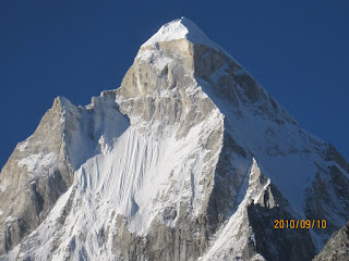
| Langtang Lirung (7200m) and glacier |
Langtang Lirung (7200m) is the highest and most impressive
peak to be seen on this trek. It lies a little to the north of Kyanjin Gompa,
and the best views are had from the summits (there are two) of Kyanjin Ri (4800m), both of which are easily accessed from Kyanjin Gompa village. From the summit, looking
North, the ground falls away to a narrow glacial valley about two thousand ft
below, the base for climbing the big mountain. Directly across this valley,
rises the enormous south face of Langtang Lirung, with sculpted features (that
treated us to a ring-side view of a big mountain avalanche, but more on that
later), and to the east, a ridge with equally impressive peaks and faces of Kimjung
and Yerba. Looking west up the valley of the Langtang Khola are a bundle of
peaks, including Yala, the graceful Gyanchenpo and several others that we spend
a good deal of time debating the names of on the way down. Across the main
valley, looking south, is a long ridge with a tangle of peaks and passes, one
of which is Ganja La. This is the high route back to Kathmandu via the Helambu
Valley.
Planning and getting there:
Rajeev finally made up his mind to emigrate to Australia in
the summer of 2018. So we decided there could be no better send off than a
Spring season trek to the mountains. The trek was on Shailesh's radar for a while, and Prasad dug up a trip report from our common friend Geetha (see Annapurna 2011) who had
trekked this route in 2017, a couple of years after the earthquake. Shailesh
did most of the research in the run up to the trip, and with Kanchen had a plan
of extending their trip by a few more days, heading up to Thale Syabru on the
way back, from where some additional views were to be had. Bala, an experienced
long distance runner was on his first trek to the Himalayas. I used my contacts
at Sacred Valley Inn Pokhara (the ever helpful Ailsa, Ganga, and Bishnu) to
help arrange a guide (mainly to help us pre-arrange permits), a jeep, and a
couple of porters.
Apr 5: Bangalore to Kathmandu
The five of us met in Bangalore Airport, downed a few beers
and some enormous kaati rolls (be warned, international travelers at BIAL) and
landed in Tribhuvan Airport around 9 pm on Thu night. Getting visas for the US
citizens amongst us turned out be much smoother than expected, and we were past
immigration hunting for our backpacks in the pandemonium of the arrival hall
within minutes. A good hour was spent after this getting everyone SIM cards
from the Government-run Nepal Telecom booth. In the end it turned out that NCELL
had far better coverage in the Langtang valley.
We found cabs quite easily, and reached Thamel, where we spent the night
at the erstwhile Sacred Valley Inn, which now has been imaginatively
rechristened “Hotel the Sacred Valley Home” under new management.
Apr 6: Kathmandu to Syabru Besi
Ram Chandra, our guide, met us at the hotel and joined us
for breakfast soon after which (around 8 am) we left in the ramshackle jeep he
had arranged. Charges: Nepali Rs 17,000 for a one-way drop to Syabru Besi! Once
we left the traffic of the city behind, the jeep labored uphill into the
mountains that surround the Kathmandu Valley, entering what we were told was a
national park area. We took a break for a snack, where Ram managed to leave his
water bottle behind, so we lost some time returning to the spot to retrieve it.
After that there was considerable confusion between him and the driver
regarding what route to take, and one point we ended up driving through what
felt like terraced fields. Finally, after an interminable and likely unnecessary
detour, we got back on the main road. What was supposed to be 140 km drive,
eventually took us about 10-11 hours, and we arrived at Syabru Besi, a
disgruntled lot. Thanks to no help from Ram, we found ourselves a place to stay
at the Buddha Guest House, which though basic, offered hot water, and tasty
food, though served at glacial pace.
Apr 7: Syabru Besi (1400m) to Lama Hotel (2500m)
We left Syabru Besi at 8 am, and walked through the new
village, showed our permits at a check point then after crossing the Trishuli
river, navigated the more interesting older part of the village. The first
couple of hours involved easy hiking, along undulating wide trails alongside
the feisty Langtang Khola, past a “Bob Marley Guest House” and the occasional marijuana patch. A drizzle started mid-morning, just around when we stopped for
a break of lemon tea, and annoyingly lasted well through lunch, which we took
at a settlement called “Bamboo” at 2000m around 12:30. Service was slow since
there was only a teenage girl running around serving a bunch of hungry trekkers,
but happily there was a fire for us to dry up a bit. A kitten had the same idea
and was curled up in a box near the fire like a dead thing.
 |
| Lunch at Bamboo |
We plodded on
through a rainy afternoon, criss-crossing the river a few times on
well-constructed metal bridges, steadily gaining altitude, stopping
occasionally to take pictures of rhododendron trees that had started blooming. At
around 5 pm, we reached Lama Hotel (2500m) a name used to denote a cluster of
sad looking lodges. The lodge we stayed at was cold and damp, nothing more than
a few boards of plywood holding the two storey structure together. The bathroom
posed interesting challenges with a door that wouldn't close, and tap that produced water at a drip, no more. Shailesh
encountered some Korean monks who would have nothing to do with the facilities,
and as a result, had his own story to tell and he wouldn’t approve of me
disseminating it over the internet. In contrast, the dining room was warm and welcoming,
so that’s where we spent most of the evening chatting with fellow trekkers and
downing bowls of noodle soup.
 |
| Rhododendrons on way to Langtang |
Apr 8: Lama Hotel (2500m) to Langtang (3500m)
We left Lama Hotel around 8:30 am. The first part of the
hike was similar to the prior day’s but got steeper as we started climbing out
of the valley. There was one chai break at a picturesque spot called “Riverside” at
2800 m. I personally found the next couple of hours challenging, thanks to a
combination of gradient, pack weight, my issues with aerobic capacity, and some early effects
of altitude.
Around 11:30, the trail reached a crest where a small meadow with light pink blooms of tall rhododendrons greeted us. We stopped for lunch around 12:30 at the “Snow Leopard Guest House” where we were entreated to spend the night, but we couldn’t since we had plans of pushing on to Langtang. There was intermittent rain through the afternoon, which enabled Kanchen and Shailesh to provide some entertainment through their frequent changes of outer wear. But the giggles subsided pretty fast once we came upon the mile long rock-slide that we had to navigate knowing that a once prosperous village of hundreds lay buried beneath our feet. A few buildings forming the seeds of New Langtang glistened on the other side of it, testament to the deep-seated human will to prevail against all odds. Far off to the left we could see a single stone building, backed by a large mountain wall and protected by an overhang that escaped the destruction, the only one to do so.
We reached New Langtang (3500m) around 5 pm, in cloudy weather that only added to the somber mood. Dinner at the “Langtang Memorial Guest House” was pleasant, in the company of a young couple from Argentina, but it also involved a chocolate pancake that belied what possibly were misplaced expectations.
 |
| Out of the valley, above the tree line |
 |
| Rock slide that destroyed Langtang. New Langtang in the distance |
Apr 9: Langtang (3500m) to Kyanjin Gompa (3900m)
Next morning broke with clear skies and a glistening partial
view of Langtang Ri (or maybe Langtang Lirung?) from the lodge itself. Bala
Rajeev and I spent some time roaming around the cold morning, climbing onto a
partially constructed terrace to get better views. The promise of a bright
sunny hike above the tree line felt great. And so it was. By 9 am, we were well
on our way, being rewarded with pristine views of the Langtang Himal range, with
the peak Gyanchenpo at the head of the valley dominating matters. The trail was
now relatively easy. So inspite of the altitude gain, I wasn’t feeling as challenged
as the previous day. We took a quick break for chai at an isolated tea shop
next to a giant boulder appropriately named “Hard Rock Café”, where we
collectively decided that sea buckthorn tea wasn’t our thing, crossed
several mani walls (perpetually confused about which side you’re supposed to be
on), and gradually made our way up the broadening valley under brilliant skies,
with the occasional chorten and imposing peaks of the Langtang Himal range all
around. Close to noon, we crossed a solid looking metal bridge from which a
portion of the giant wall of Langtang Lirung and a glacier tumbling down its
face made an impressive appearance. Immediately
after lay a cluster of buildings with blue roofs. This was Kyanjin Gompa (3900m),
the last and highest permanent habitation of the valley.
 |
| Sunny skies just as we left Langtang |
 |
| Family run lodge at Langtang |
 |
| Gangchenpo (6300m) at the head of the valley |
 |
| Kyanjin Gompa Village (3800m) |
The lodge we chose (“Lovely Guest House” run by Penzom and
Jhandu Lama) was comfortable and the owner turned out to be a mountaineer
himself, leaving the running of the lodge to his wife. Kanchen and Shailesh shared
one room, Bala and I another, and Rajeev got a room all to himself. It was
definitely a step up compared to the lodges lower down in the valley. The
clouds rolled in during the afternoon, which was fine, since we didn’t really
have big plans of doing much more hiking that day. We walked over a bit beyond
the village to a point where you get good views of an enormous glacial plain and then as the drizzle started, we scampered back to the very well-endowed “Dorje Bakery”. Though the proprietor had a terrible case of the flu,
the coffee they served was undeniably the best in the entire valley.
Apr 10: Day hikes around Kyanjin Gompa
We woke nice and early to enjoy the early morning clear
skies. Bala and I went for a pre-breakfast hike around the left of Kyanjin Ri (a
“hill” rising sharply behind the village that we planned to climb the next day)
to approach the base of the formidable Langtang Lirung. I was pretty motivated
and feeling unburdened from not having to carry my rucksack. After a few false
starts, we finally found the trail, and Bala stayed ahead of me, route-finding
his way up the narrow glacial valley. We got to a point where we got
unobstructed views of the glacier, a formidable icefall, some glacial pools,
and the immense face of Langtang Lirung. Feeling sufficiently rewarded, it was
a quick scamper back to the lodge for a hearty breakfast (I think I had 4 eggs),
on the way we had a brief conversation with an elderly white couple who had to
be in their mid-late 70s.
 |
| Snow peaks to the south of Kyanjin Gompa including the Ganja La route to Helambu Valley |
 |
| Icefall near the base of Langtang Lirung |
 |
| View from the day hike towards the base of Langtang Lirung |
Later that the morning all five of us lazily walked up
the valley to get better views of the glacial plain, and reached a side valley
that proved a bit tricky to negotiate. So we descended along it towards the
plain and reached a point where Kanchen and I decided we had had enough. The
two of us sat ourselves down and enjoyed a game of target practice (that
Kanchen won hands down) while we watched the others descend to the plain and
become ant-like objects, and then slowly make their way back.
 |
| Glacial plain to the east of Kyanjin Gompa |
The area east of Kyanjin Gompa is known for a few minor
summits in the 4500-5500m range including Yala Peak, several of which are popular
among the more ambitious trekkers. We had not prepared ourselves either
physically or in terms of time to attempt any of them. But it left open the
possibility to return with more preparation and visit some of the higher
reaches of this beautiful valley.
In the afternoon, during the customary drizzle, we visited
another café, which turned out to be mere a pretender compared to Dorje.
However, the proprietor did impress us with the fact that he had a helicopter
fly in a giant oven for baking and his espresso machine.
Apr 11: Kyanjin Ri (4800m) and walk down to Langtang
We wanted to make an early start to climb Kyanjin Ri, but
the weather looked uncooperative. Finally, we got started among swirling mist
at around 6:30 am, with teasers of blue sky occasionally breaking through the
shroud. The view of the giant Langtang Lirung was spectacular, even on the
lower reaches of the hill. Every few minutes it would get obscured by cloud
only to reveal itself a few seconds later. The ascent was slow going, especially
for me, as I could feel the effects of altitude. But I was able to find a
walk/break routine that I could sustain. Bala was far ahead, barely within sight, and
Kanchen, Shailesh and Rajeev were a bit closer. The four of us halted for a small
snack and a weather check, after which most folks decided to head back down. The
snack did me some good, and I felt there was nothing to lose by plodding
onwards, since the likelihood of rain seemed low. So I kept going, one step at
a time, and finally reached the first of the two summits at 8:30 am.
 |
| Avalanche on Langtang Lirung |
 |
| Langtang Lirung from Kyanjin Ri |
 |
| Icefall further east, possibly Yala Peak? |
 |
| Gyanchenpo from Kyanjin Ri |
 |
| Ridge leading to second summit of Kyanjin Ri |
 |
| Glacial plain east of the village backed by snow peaks to the south including route to Helambu Valley |
The reward
was incredible. Apart from the views of the peaks all around, it so happened
that a major avalanche rolled down the massive face of Langtang Lirung at the
very moment that I was busy taking pictures of it. Barely a mile away, it was a
unique (and fortunately safe) place to witness a powerful force of nature. The
avalanche crashed into the valley below, not far from where Bala and I went
hiking the previous morning, and the mist from it gradually rose and enveloped
the handful of us who were standing atop Kyanjin Ri, making a bunch of strangers
shake hands and grin at each other. Bala had meanwhile taken off, hiking along
the lovely ridge heading towards the second summit, from where he’d likely get
a different vantage a perhaps a better view of Yala Peak.
All of this was now backed by a brilliant blue sky that just
an hour previously, did not seem forthcoming. The wind was playful. One moment
it was still, warm and sunny. Then it would whip the prayer flags at the peak
into a frenzy and force me to huddle among the rocks. I sat at the summit of
Kyanjin Ri for nearly 45 minutes taking this all in, before jogging back down
the hill to Kyanjin Gompa.
Back in the village, breakfast, and excellent coffee at
Dorje’s followed a reunion with Bala who took the long way down from the second
summit (and truly earned his meal). We bade friendly goodbyes to the Lama couple,
and started making our way back down the valley around noon. On the way out of
the village some of us made the short detour to the actual Gompa from which the
village takes its name. In a couple of hours, we reached New Langtang and it’s
mani walls and stopped for the night at the same lodge where we stayed on the way up, the
chocolate pancake disaster notwithstanding.
 |
| Dorje Bakery was something special! |
 |
| Goodbyes at Kyanjin Gompa |
Apr 12: Langtang to Rimche
It was a brilliant morning with some overnight snowfall, so
the cameras got busy right from 6 am, trying to capture the first rays of the
sun on Langtang Lirung, at least the portion of it that is visible from
Langtang. We left Langtang around 8:40, with a plan to head beyond Lama Hotel,
where the accommodations were less than stellar, and push on to Rimche, about
30 min further. The clouds came in as we descended into the rhododendron
forest, which were now in a more advanced state of bloom (whites, pinks, reds
all around). After a lunch break at Riverside amidst a
drizzle, we walked straight through the joyless terrain of Lama Hotel, and climbed
up to Rimche, a pretty spot, perched on a ridge at 2500m with a couple of tea
houses. The toilet here was something unique, and Bala's euphemistic and cryptic description of it being a tad "claustrophobic" didn't prepare you for the wicker basket for used tissues that was precariously installed about 5 feet high on the door. So as you went about your business, you were better off practicing your basketball skills to ensure they landed in the right place, and pray that yours not be the one to break the proverbial camel’s back.
 |
| Sunrise at Langtang Village |
Apr 13: Rimche to Syabru Besi
We left around 9 am, and enjoyed the easy downhill hike to Bamboo, where we stopped for some tea. Immediately after, there was a nice
stretch of the river where we washed up, and Shailesh showed off some of his
core strength. It seemed like a popular spot for westerners to go swimming. Later
we passed the turn off that would have taken Kanchen and Shailesh along a
tentatively planned side trip that leads to Gosaikunda. In the end they decided
to spend their extra days visiting Pokhara (where unfortunately the wet weather
followed them). The last stretch seemed longer than we remembered it, and it
was as late as 1 pm by the time we strolled back into Syabru Besi. A good meal
was downed at a restaurant opposite Buddha Guest House, while the cab was being
loaded. The long jerky ride back to Kathmandu, coupled with post trek fatigue led
to a few frayed tempers, but nonetheless after a brief dinner stop at a hotel in
a busy market area, we reached Thamel in one piece around 9 pm in the evening.
 |
| Langtang Khola making its way to Syabru Besi |
Apr 14: Bumming around Kathmandu
Most of us were looking forward to an easy recovery day. We
spent the morning strolling around Durbar Square which bore signs of
significant damage from the earthquake, and follow-up aid from the US and China for
reconstruction. Rajeev got a spa treatment, Kanchen and I got our potato chips
fix, and we all met for an excellent lunch at my favorite Fire and Ice Pizzeria (not before
Google Maps nearly made us scale a 10 foot wall). At lunch Kanchen did a
Captain Haddock (that too in Kathmandu) by consuming a spoonful of chilli
flakes, assuming they were something else (“Fresh fruit? Good to eat?
H-A-A-A-H!!” -- see Tintin in Tibet). Some customary shopping for hiking gear in Thamel followed, ended
by a slightly weird evening in a bar that purportedly was famous for live
music, but we ended up being the only audience. So we left, and headed to the
“real” scene, a Mediterranean restaurant in the heart of Thamel that was just
insanely popular with local youth and Israeli visitors.
 |
| Durbar Square, Kathmandu |
 |
 |
| Great pizza for weary travelers! |
Closing thoughts
Langtang is a classic Nepal tea-house trek of
moderate difficulty with great rewards. There’s really no need to take a guide
if all you are doing is going to Kyanjin Gompa. Advanced trekkers will find it worth
exploring the valley beyond, and perhaps attempting one of the summits in the
area. For this, a guide is recommended, and such endeavours carry the usual caveats
regarding knowing your limits, etc. From what we saw, it should be possible to
arrange a guide after reaching Kyanjin Gompa, but make sure you have enough days. A
great loop route would be to ascend via the Langtang Valley and exit over the
Ganja La pass and return to Kathmandu via the Helambu Valley. Not sure about
difficulty levels though. On a personal note, this was something of a milestone for
me. Post-surgery, this was my first “real” trek --- Darma Valley was quite easy
(and short) in comparison to this. I was quite pleased that I was able to
handle my rucksack on the walk in, and also manage the hike to Kyanjin Ri.
P.S. It's been over a year since this trip was completed, and though procrastination was the primary reason for the delay, I can't help attributing part of it to a barrage of (mostly) good humored existential questions that were raised by a certain fellow traveler.

Comments
Langtang Valley Trek